I understand the need to recover a family member. A couple of year’s ago, there was a tragic accident on the Blackstone River a couple miles downstream from where this couple got stuck on the strainer. A father and son in a tandem canoe tried to run the tubes at the Pratt Dam.
The boat got hung up on one of the piers and pinned. The father flushed through, but the son drowned when his foot got wrapped up in the painter line.
https://www.americanwhitewater.org/content/Accident/detail/accidentid/2855/
This accident led to interesting discussion here on safety and painter lines.
https://forums.paddling.com/discussion/1007581/secure-those-painters-fatality-report
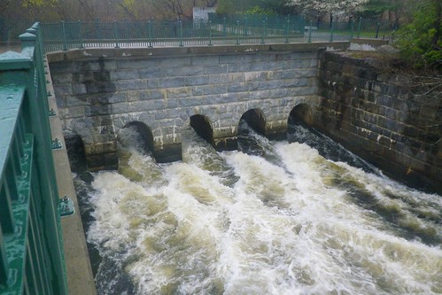
Anyway, back to my point, they lowered a huge metal plate to block the middle tube so they could recover the body.
https://www.youtube.com/watch?v=l8Ym_KJ7ths better sense of what the two women encountered
Very sad. As the one guy said, you can’t see the damn from upstream which means if they didn’t study the map they never saw it coming.
I have long thought that the Corp of Engineers could do a better job of posting warnings on the low head dams around here. I’ve seen much better signaling systems in other parts of the country, like bright orange strung floats and flashing lights plus very obvious warning signs that illustrate the dangers at all of the adjacent launch points. This particular dam is 1585’ across. Having a couple of buoys with black and white signs on them and a low profile string of white floats is pretty lame (though the COE claims that the warnings exceed minimum requirements for such locations.). You can see the installation there now in the pics in the links below.
But I see this morning that the uproar caused by this incident has prompted planned enhancements to the warnings. One bright spot in this terrible tragedy is that (I hope) it has brought greater public awareness of the dangers of these dams in our area and beyond to people thinking of boating near them. I believe too many people think a “dam” is just a wall across the water that they will safely bump up against and then turn around and paddle back.:
http://www.post-gazette.com/local/north/2017/05/26/Kayakers-Dashields-Lock-Dam-Brittany-Evans-Helene-Brandy-Ohio-River-Emsworth-buoy-pittsburgh/stories/201705260291
http://www.post-gazette.com/local/city/2017/05/23/missing-kayaker-pittsburgh-dashields-locks-dam-ohio-river-low-head-dam/stories/201705230185
Good video by a friend of mine showing the very similar dam, Highland Park on the Allegheny River, one of the Ohio River feeders maybe 22 miles upstream from Dashields Dam where the women were killed. The clip shows how smooth and hard to see the drop is from the upstream side and also how violent the recirculating current is in the downstream roil, http://www.youtube.com/watch?v=3-z7StXytsI
@willowleaf said:
The clip shows how smooth and hard to see the drop is from the upstream side and also how violent the recirculating current is in the downstream roil.
That horizon line always indicates a drop like a dam or a ledge. River paddlers looks for it. With our history of water power for industry, there are a lot of dams in the northeast. On the Blackstone River near me (first accident in this post) there is a dam on average ever 4 - 5 miles. The rivers around here are nowhere near as wide, so it is much easier to post warnings upstream. Around here, people are more likely to get sucked in from the bottom than go over the top. I’ve seen truck tires getting recirculated in there.
I saw a table somewhere (forgot to index the link) that indicated that Pennsylvania has one of the largest numbers of low head dams of any US state, though hundreds have been removed in recent years. Also among the top 6 states in dam-related drownings.
I’ve seen some photos of the approach to the lip of Niagara Falls from upstream – it just looks like rapids and some raggedy islands. From the water level only the cloud of mist rising above the horizon line would be the clue of the horrific drop below.
@eckilson said: > That horizon line always indicates a drop like a dam or a ledge. River paddlers looks for it.
I would add that “educated” paddlers know to look for the horizon line. Based on my observations and conversations with most of the folks I’ve encountered over the years launching their new recreational kayaks in our area, the majority percentage are not familiar with that term or the reality of dams.
Apparently the second lost kayaker’s body was recovered today, about 4 or 5 miles downstream by the fire department and fish and game search teams. The coroner will have to confirm ID via dental records – they mercifully spared the family from making physical ID, not a memory they need to have after she was in the water for over a week.
http://www.post-gazette.com/local/city/2017/05/29/helene-brandy-pittsburgh-missing-kayaker-body-found-ohio-river/stories/201705290063