I need to purchase a new one. My old Garmin (76sc I think it might be) finally started to develop condensation in the window. Maybe I should have maintained the battery compartment seal better, I don’t know but I got it a few years ago and until recently has performed flawlessly (and it floats). Anyhow, I am inclined to get what appears to be a newer version of the same unit, the GPSMap 78 color . The GPS store.com has it for $164. Wanted to check in and see if anyone has a unit (any model) they really love, or perhaps more tellingly, had problems with any particular units - i.e., ones to avoid - whether it is due to the unit failing with use or just poor functionality to begin with. I mostly use mine to check speed or help me navigate back to a launch site in areas with lots of islands or marshes or just generally, non line-of-sight navigation. Thanks.
I carry a Garmin GPSMap78sc (includes preloaded US coastal charts, electronic compass and barometric altimeter) as a primary, and a GPSMap78 as a backup (when backup is needed for expeditions, Watertribe races). If I had to choose between the two, I’d pick the GPSMap78sc, although it is more expensive. That said, it may depends on whether you already have charts/TOPO maps, or if you need to buy them.
In addition to charts the GPSmap78sc includes an electronic compass, that can be useful at times, but I normally have that turned off to increase the battery life (which is impressive).
Greg Stamer
@gstamer said:
I carry a Garmin GPSMap78sc (includes preloaded US coastal charts, electronic compass and barometric altimeter) as a primary, and a GPSMap78 as a backup (when backup is needed for expeditions, Watertribe races). If I had to choose between the two, I’d pick the GPSMap78sc, although it is more expensive. That said, it may depends on whether you already have charts/TOPO maps, or if you need to buy them.In addition to charts the GPSmap78sc includes an electronic compass, that can be useful at times, but I normally have that turned off to increase the battery life (which is impressive).
Greg Stamer
I see that gps for 249.00 I can’t believe West Marine is cheaper than gps store. When I buy boating parts and supplies West Marine usually through the roof on prices.
I see the speed limit on GPS is 999 mph.
OK, I’m trying to decide between the two units - the GPSMap78 and the GPSMap78sc. I definitely don’t need the compass or barometer that come with the 78sc. And I can’t think of a compelling reason why I would need the coastal charts either, but maybe there are such reasons. I can’t think of any reason I would need navigational aid info such as buoy markers and lights etc (the GPS itself would tell me what I need to know). Maybe there would be an occasion where I would use it to make sure I was not in a shipping channel in a busy harbor. I suppose the depth info might be useful in avoiding some of the large areas in Atlantic and Gulf coast bays (often behind barrier islands) that are often so shallow as to become unpaddle-able when the tide goes out (never gotten stuck but I’ve read stories). Generally, for the infrequent occasions where I am paddling somewhere I am not familiar with, I would have a paper chart or would have consulted one during the planning phase though. I WOULD be inclined to get the 78sc if it had better mapping of salt marsh channels and very narrow winding creeks that empty into a bigger body of water compared to the GPSMap78. I don’t know if it does or not. Greg, if you’re still reading this thread, what say you? Anyone else? Thanks.
The question would be what maps/charts do you intend to load and use?
You can load whatever compatible maps you want on either unit. If you intend to use Garmin’s bluechart series, they are already loaded on the 78sc (for the coastal US), you will have to buy them for the 78 (and they are not cheap). I also have Garmin’s TOPO maps installed on mine, and I switch back between the marine charts and the TOPO depending on which works better for my particular use. I use the marine charts about 90% of the time.
That said, if you don’t need the compass/barometer, and you don’t need the bluechart, then there’s no need to get the 78sc. Otherwise the capabilities are almost the same (78sc has some features like wireless sharing of information to any 78sc). A comparison chart is at http://www.gpscentral.ca/products/garmin/gpsmap78seriescomparison.html .
Greg
What I’m specifically wondering is whether or not the Base Map (which I assume is sort of like a Road Atlas) would allow one to navigate through a winding salt marsh channel for instance, or to the tip of an uninhabited barrier island…or are those types of ‘land’ forms only shown with the BlueChart option…
Also, I looked at that table. What is “Photo Navigation.”
Thanks
Dave
I think photo navigation has to do with navigating to a metataged location a picture was taken-I suspect it is a geocaching thing. That said, downloading satellite photo overlays seems pretty cool. I really need to sea if my bigger unit can do that trick.
Hmmm, I tried an experiment once, taking pictures with my phone as I was leaving a launch point with the thought that they might be useful on the way back (the areas was a large inland lake [Lake Lanier in GA]. Even though I know the area fairly well, from a distance the various coves look pretty similar and I’ve paddled into the wrong cove before, before realizing it and then spending an extra 40 minutes or so getting to the next one in the hopes that that was where the ramp was. Besides just not wanting to stop on my way out to take pictures, it’s hard to see the screen on my phone in daylight so I didn’t pursue that navigational memory aid.
The Garmin basemap has extremely little detail. Basically it gives you crude block outlines of islands and land, and major roads such as interstates. Realistically, you will need to load some kind of map/chart, such as marine bluechart or TOPO for real-world kayak navigation. FWIW, there are some free TOPO maps that you can download, if you are tech savvy.
That said, a GPS78 will give you a detailed track of where you have been, that you could use to find your way back (like a breadcrumb trail), even if you were using a basemap or other low-quality map. You wouldn’t see much detail of water/land features, but you could see your detailed track, and follow it.
Photo navigation is to allow you to navigate to geotagged photos. I have never used that feature, so can’t report on how well it works, or its usefulness.
Greg Stamer
Thanks Greg!
Pictures speak louder than words. Here’s some examples of the same area (at much less than full zoom) that might help illustrate some of the map/chart options:
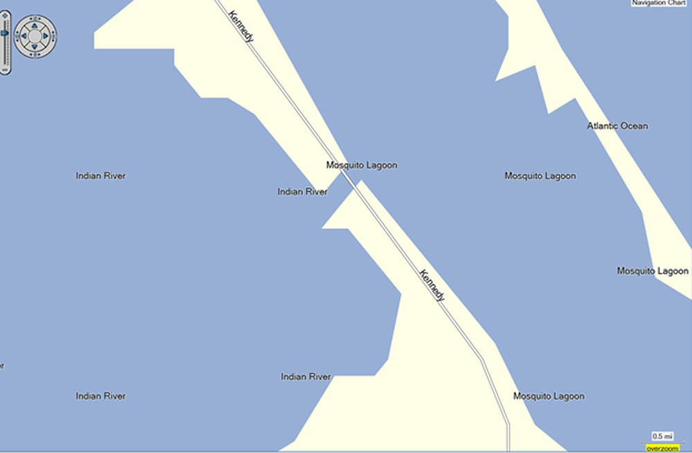
Basemap
http://www.gregstamer.com/images/BasemapExample.jpg
TOPO US 24K
http://www.gregstamer.com/images/Topo-US-24-Example.jpg
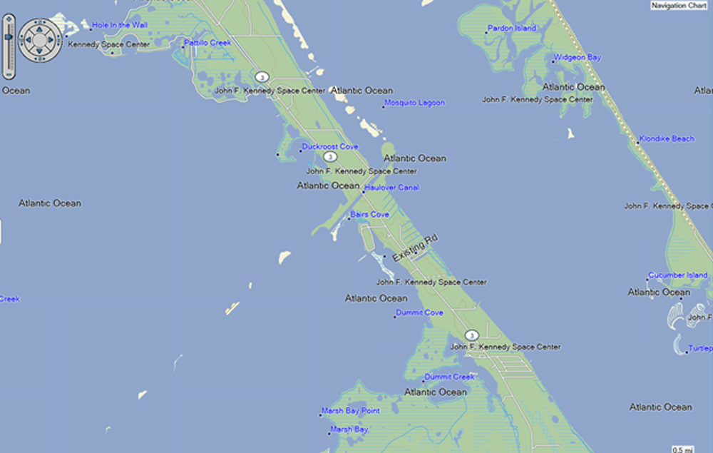
BlueChart
http://www.gregstamer.com/images/BlueChartExample.jpg
Greg
Having somewhat old eyes (!) I found myself thinking that the newer Garmin “trail” GPS units had bigger displays, but when I compared the display dimensions to my old reliable Garmin GPSMAP 60csx I was surprised to find out that the display on those new smartphone-like units were only marginally bigger than my old reliable. Don’t be fooled by the apparent display size!!
From what I gather the biggest difference in the newer units is that their handling of non-Garmin maps has been much improved. From what I understand, these days you can get maps for your GPS from many different sources (if they exist).
Earlier in the thread gstamer mentioned that the electronic compass was not needed. Even though I know how to use a magnetic baseplate compass - and carry one when out and about - I actually have come to really like that my GPS’ electronic compass allows me to know which direction is which while using the GPS - without having to be moving.
I think the barometer can be used for two purposes - (1) in association with determining altitude (in the U.S. midwest that is not a need for me, and (2) if you watch it maybe you’ll be able to take note of approaching weather changes. In my case I never seem to notice it. My little weather radio does a much better job IF I can receive a station from where I’m at.
Ken K.
I see (very helpful to see those pics side by side)!! Well, I think I’ll splurge and get the 78sc.
@gstamer said:
Pictures speak louder than words. Here’s some examples of the same area (at much less than full zoom) that might help illustrate some of the map/chart options:Basemap
http://www.gregstamer.com/images/BasemapExample.jpgTOPO US 24K
http://www.gregstamer.com/images/Topo-US-24-Example.jpgBlueChart
http://www.gregstamer.com/images/BlueChartExample.jpgGreg
It was me, the OP, who said I don’t need the electronic compass. It’s a nice enough feature I suppose but I have a pretty visible Seattle Sports compass just ahead of the cockpit and in reality, I don’t even use that very often (I mostly paddle in familiar territory). Fortunately (well, depends on how you look at it), I’ve never been paddling in an area where I couldn’t pick up a weather channel.
@KennK said:
Having somewhat old eyes (!) I found myself thinking that the newer Garmin “trail” GPS units had bigger displays, but when I compared the display dimensions to my old reliable Garmin GPSMAP 60csx I was surprised to find out that the display on those new smartphone-like units were only marginally bigger than my old reliable. Don’t be fooled by the apparent display size!!From what I gather the biggest difference in the newer units is that their handling of non-Garmin maps has been much improved. From what I understand, these days you can get maps for your GPS from many different sources (if they exist).
Earlier in the thread gstamer mentioned that the electronic compass was not needed. Even though I know how to use a magnetic baseplate compass - and carry one when out and about - I actually have come to really like that my GPS’ electronic compass allows me to know which direction is which while using the GPS - without having to be moving.
I think the barometer can be used for two purposes - (1) in association with determining altitude (in the U.S. midwest that is not a need for me, and (2) if you watch it maybe you’ll be able to take note of approaching weather changes. In my case I never seem to notice it. My little weather radio does a much better job IF I can receive a station from where I’m at.
Ken K.
Just to clarify, I didn’t say that the electronic compass was not needed or not useful. In fact I said it could be useful at times. The compass is one reason that given the choice of one unit, I would pick the GPSMap78sc. That said, I turn the compass off for long-distance (Watertribe) races simply to maximize battery life as it contributes to battery drain (I have a GPS running at all times when I am racing). As you state, the compass does keep the GPS oriented when you stop moving, which is a nice feature (otherwise the GPS has no idea were you are heading, which can be confusing). That said, I try not to be at a standstill very often, during a race… 
Greg