My girlfriend and I will be spending a few days in the area, and at least one of those days we would like to spend kayaking. I have spotted a few boat launches in the area on Google Maps and the Go Paddle app, but being unfamiliar with the area I’m wondering if anyone here has any suggestions of a good place to put in that has decent parking, and some suggestions for places to paddle to for some sight seeing by water. We have immersion wear, suitable kayaks for ocean paddling, communication, safety, and navigation gear.
My son is now in that area, so I hope to do some paddling up there, but haven’t yet. There is so much coastline that it is almost overwhelming. If it was me I would probably start here:
I’m in a canoe, so I tend to look for places that are a little more protected. Maine Island Trail has a great guide with all the boat launches, but it is hard copy only for members - worth the money if you have time to order it.
Maybe kayamedic or one of the Mainers will weigh in.
1 Like
If you want to tour the Harbor, there is a launch on Atlantic Ave in Boothbay Harbor Next to a building that says “Boothbay Harbor Fish Pier” on the front. You can park in the lot behind a church across the street. Just make sure you park all the way in the back by the trees to be courteous.
And after you launch definitely make sure you take a good look around you on your way out to get some visual cues as to where it is for your way back. It can be hard to find, because of the large difference between high and low tide there. Buildings or signs work good.
There are a lot of really great places to go in that area. Sometimes you have to drive quite some distance to get to a launch that’s not very far away by boat - one place I love to paddle out of (Port Clyde) is 10 miles from where we stay by kayak, and 35 miles by car.
Off the top if my head, I’d recommend launching out of South Bristol and the head down to Christmas Cove and a chain of islands south of there, or go the other direction from the launch, and head up the east side of the shore.
Just pay serious attention to tides around there. The currents can be really strong in a lot of areas. Don’t know your skill level, so I had to say that.
Anyway, you almost can’t go wrong scenery wise no matter where you go.
1 Like
Wayne Smith has good suggestions, and Christmas Cove is pretty. I agree with suggestions to stay on the protected side of things. You can launch for ex from Ocean Point (no services or portosan there), but you are in the thick of things immediately from there. And do not discount the action around the southwest side of Dammariscove Island if you try to go further out, it gets big and the only landing point is after you have gotten thru it.
One thing to be aware of paddling out of Boothbay Harbor is lots of boat traffic, and lots of sailboats. If you have not paddled among sailboats before get a sense of how they will be tacking. I have been with kayakers thru there and while it is pretty, have seen more than one of them get in the way of a sailboat.
Wayne refers to a nice paddle. Lots of bail out options and a place to land for a bit at the end is to go out of S Bristol and follow things out to Little Thrumkapp. Little Thrumkapp is landable for a break. Nicknamed the Thread of Life, that passage.
One caution in launching from S Bristol on the mainland, there is a bridge to Rutherford Island that generally is best gone under if you hail the operator via VHF for clearance. It is narrow and boats coming in from the south really cannot see you in there. So might be better to go thru the gut - it is pretty - and come down the east side of Rutherford.
I think a few of us paddled to Squirrel Island. Landing is fairly restricted and there is not really anything for you to do once you have found some place to rest for a few minutes.
Note that parking is absolutely horrid in Boothbay Harbor in the summer. So if you want to try for an in-town launch, get up and arrive early. Like at opening.
1 Like
Another alternative that I really like is Knickercane Island Park on Barters Island Road. It has plenty of parking and is relatively protected… A circumnavigation of Barters is about 12 miles. Go up to the awesome Oven Mouth Preserve…so pretty. Or if conditions are favorable go down to Hendricks Head Lighthouse and around Southport island.
Ocean Point can be glorious or horrid. Sometimes it hides north winds. We scuttled many a paddle pre Windfinder app because it looked calm but sending a scout around the corner revealed four foot waves from the north. The paddle to Damariscove is a gem if conditions allow though the entrance to its harbor can have wild waves.( there are ledges under)
Because S Bristol is so close and not close by car I wouldn’t spend time driving there to get to the eastern approach.
Keep all the alternatives in mind as you plan your outing. If one isn’t a good idea likely another is.
Be advised the narrower the passage the stronger the tidal current especially where there is a river involved. The Sasanoa can run 7 knots with whirlpools at full ebb. Towsend Gut can run some big rollers ( between Boothbay and Southport Islands)
The route I suggested at first seems to be in my experience the most benign… 13 foot tides are normal.
I recommend using either www.windfinder.com or www.windy.com and do not forget to correlate those findings with your tide findings. A north wind with an ebb tide is exceedingly deceptive. Looks flat calm… Until you get out there and realize there is no getting back. Conditions depend on the interaction of wind and tide.
2 Likes
The paddle from South Bristol to Little Thrumcap Island is definitely a good one. You can circumnavigate Rutherford Island and follow the Thread of Life chain of rocks/islands on one side of Rutherford and then poke into Christmas Cove on the other side. The little lift bridge at the gut is fun to go under and as Celia said, it’s safest to use a radio and ask the bridge operator to look if there’s a boat coming from the other side. But otherwise, just be sure to go under the bridge when it’s not open - that way any oncoming boat will be something small.
I do that paddle several times each summer (actually a bit longer by launching from Colonial Pemaquid in New Harbor). But it’s a 40 minute drive from Boothbay Harbor. You might want to stay closer. Knickercane at Boothbay is definitely a nice launch with great parking and as an alternative to going North around Barter’s Island you can also go south. That route takes you past several islands, including Powderhorn and Spectacles that you can land on.
Thank you all! I appreciate all of the advice here. Especially the detailed reports of conditions at different places. Your knowledge and input are invaluable. My girlfriend is more of a casual paddler, and would not be comfortable in extremely strong currents or rougher conditions, so I will be frequently checking the weather and marine forecasts and conditions prior to going. I downloaded the Windfinder app and saved a few locations at different points in that area. I’m also downloading charts of the area from NOAA to print and laminate, because while I do have a waterproof phone case, I don’t trust the cell signal on the water or the battery life.
Our entire paddling trip would most likely be under 10 miles, so it is unlikely that we would be venturing out to the outer islands. How is the wildlife viewing in the area? She has never seen a seal and would like to if possible.
Seals are whelping their pups starting soon and well into July. They WILL dive into the water at the sight of a kayak - and from a fair distance - and the youngest pups can be lost if they end up swimming too soon. If you see what seems to be a pile of rocks that is moving and there is ANY bright white in it, STAY AWAY. The white spots are the very young pups.
The best time to see them is at low tide when they are hauled out on rocks. Mostly Harbor closer in to Boothbay though a few Greys too. Harbor seal heads look like Labrador Retrievers and Greys like horse heads.
All that said, unless someone else here has a better idea I suggest that if seeing seals is a priority you check out a larger boat tour. The only places I have hit then reliably are in locations that are l questionable for what you describe. One tour here, you could call them and find out what trip is most likely to get you seals. Boothbay Harbor Cruise: Lighthouses, Lobster Haul, and Seals | GetYourGuide
It is frustrating; a motor boat can stand practically on top of them and they often don’t care. But they will not tolerate kayaks.
Get the tide charts for Boothbay Harbor too. Free to print if you don’t mind them in black and white, or online, from US Harbors.
1 Like
Good to know! I definitely don’t want to spook them and cause them any undue stress, especially the pups.
For a relatively easy, protected paddle close to Boothbay, I’d go with the Knickercane south route that I mentioned above. Indiantown Island is also an accessible preserve, so with Powderhorn and Spectacles there are three places to stop. Plus the total length of the trip is completely flexible - just putter around the islands until you’re ready to head back. From the launch, you probably want to go North just a bit and then turn southeast down the Back River. Less current and good for any tide that way.
The most consistent seal haul-out I know of that’s in close is Knowles Rocks in Johns Bay (near Pemaquid Beach). Accessible from either Colonial Pemaquid or South Bristol. Their rock is the southeast-most of the group of rocks. But as Celia said, bring binoculars and give them lots of room.
1 Like
It is frustrating that you can see seals at lower tides by motorboat and something about kayak spooks them from farther off. I have heard various theories why,
Yesterday we played tourist and took the Maine Maritime Museums circumnavigation tour of Georgetown and Aroswic Islands. The tide was lowish just starting to flood… We saw a lot of grey seals and harbor seals hauled out. I wanted to get a pic of one and I was able to ( not sure yet how good it was). We did this tour because we have done most all of it in bits and pieces by kayak yet wanted an overall nostalgic trip( its about 40 miles total) to see if our memory of the currents of Upper and Lower Hell Gate on the Sasanoa were that bad( yes they are!) and to have our one tourist lobster chow at Five Islands before the crowds got bad in July and August.
Saw about 12-18 eagles too so don’t forget to look for them.
Our usual launch is from Winslow Park in Freeport . Free for us oldsters and a nice launch and only 40 min from home. There are a few ledges that we see seals at but in our yaks they notice us from far off and follow us… Yet everytime I try and get a pic…I have tons of pics of “where the seals used to be”
Take a look at a chart and a tide table and pick a location that has exposed ledges at low tide for the best chance. You may see but you may not be able to react enough to get a pic… And look for what looks like bowling balls in the water… They will be watching you.
1 Like
I have only ever seen two seals, both from a distance. The first was in Freeport when we took our intro to sea kayaking class at LL Bean. It was just floating a ways away, watching everyone, probably thinking we were a bunch of dumbasses flipping over and climbing back in our kayaks and paddling in circles. The second was next to Whaleback Light between Kittery and Newcastle NH. At first I thought it was a lobster buoy, but then it disappeard and popped back up in another spot. It seemed curious, but still skittish. I kept my distance and the seal did the same. I tried to get a picture, but like you, I just got a picture of the water where the seal used to be.
I lucked out once with the camera pointed the right way, the lens zoomed and my hand steady and got this one. This is near the Thread of Life ledges. You can see them pop up there quite often, but they don’t seem to haul out there as much as some other spots.
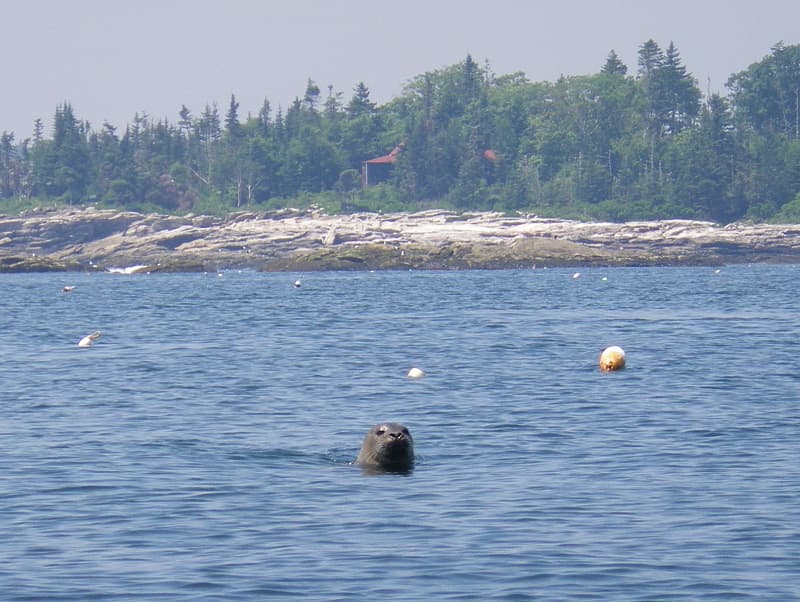
2 Likes
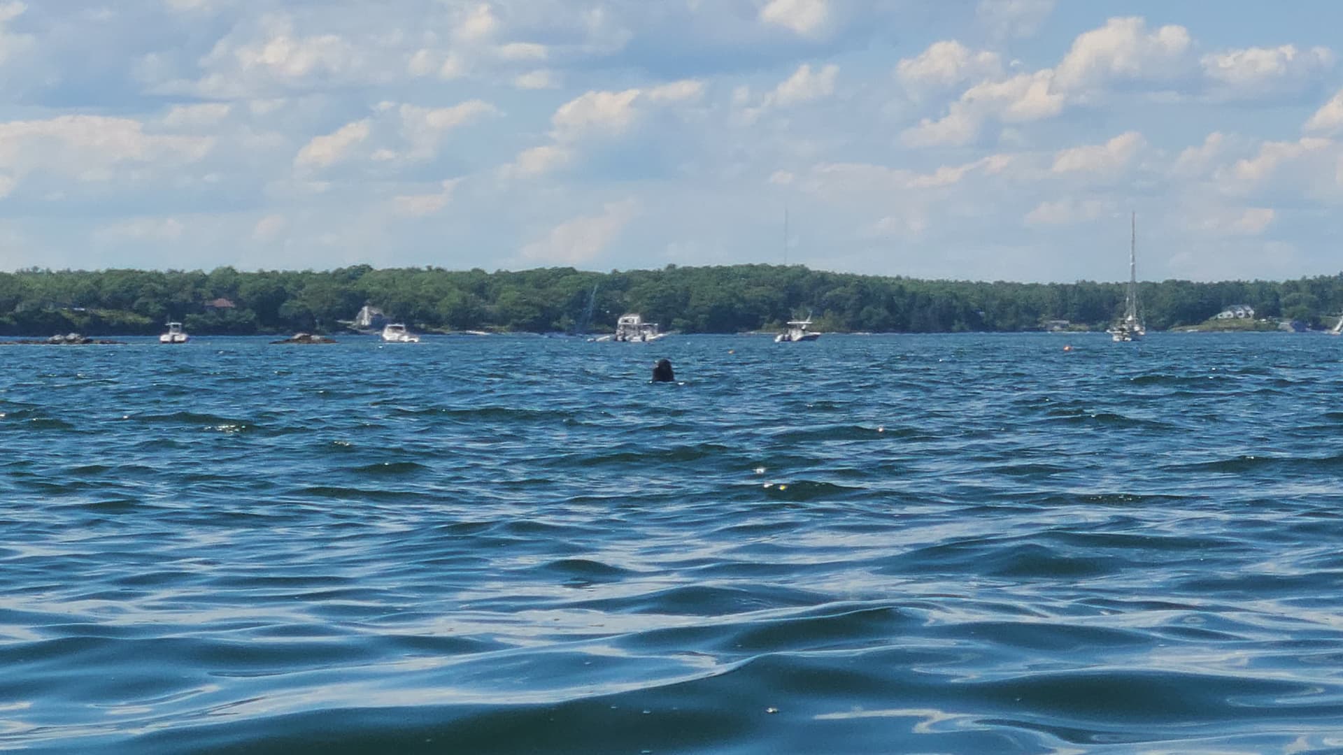
We saw a bunch of seals in the water between Powederhorn island and Boston island. Every time I got my phone up to take a picture, they would duck down below the water. I did manage to get this one though. The quality is horrible because of the waterproof case I had my phone in, and it could probably pass as a photo of the Loch Ness Monster.
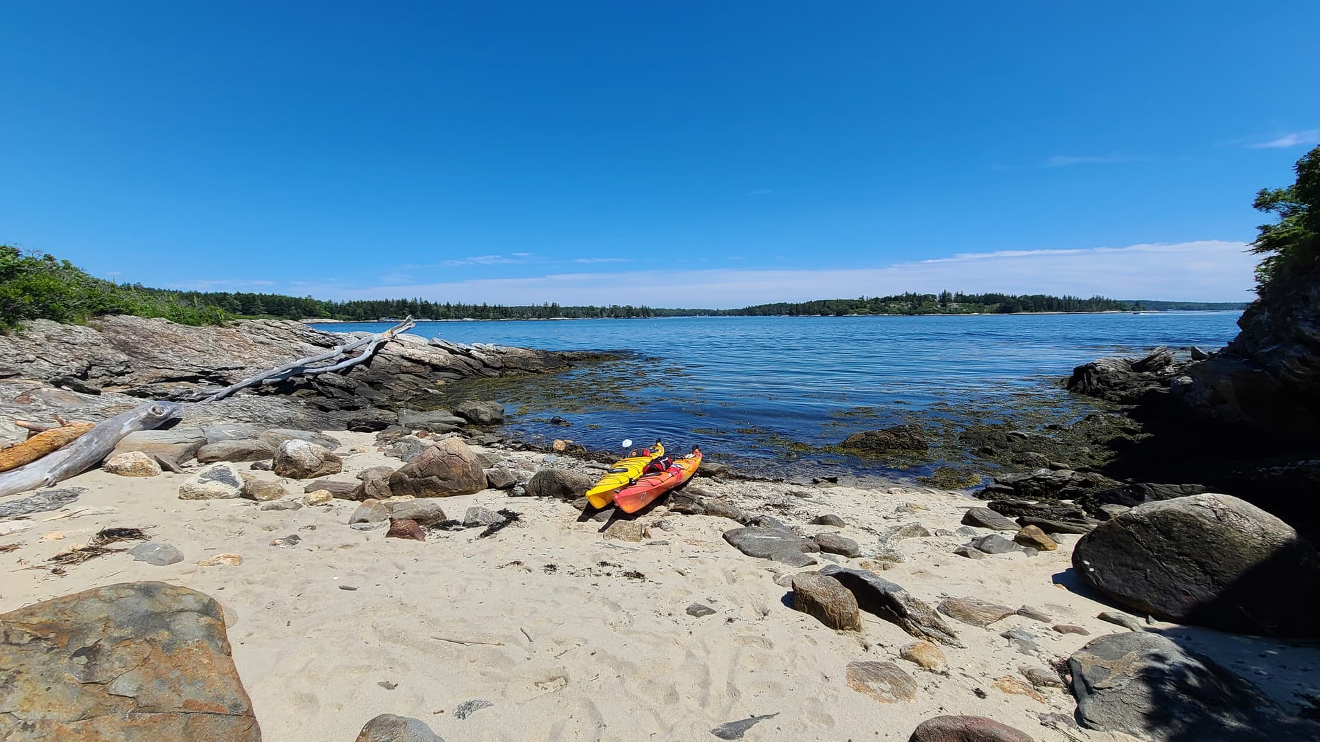
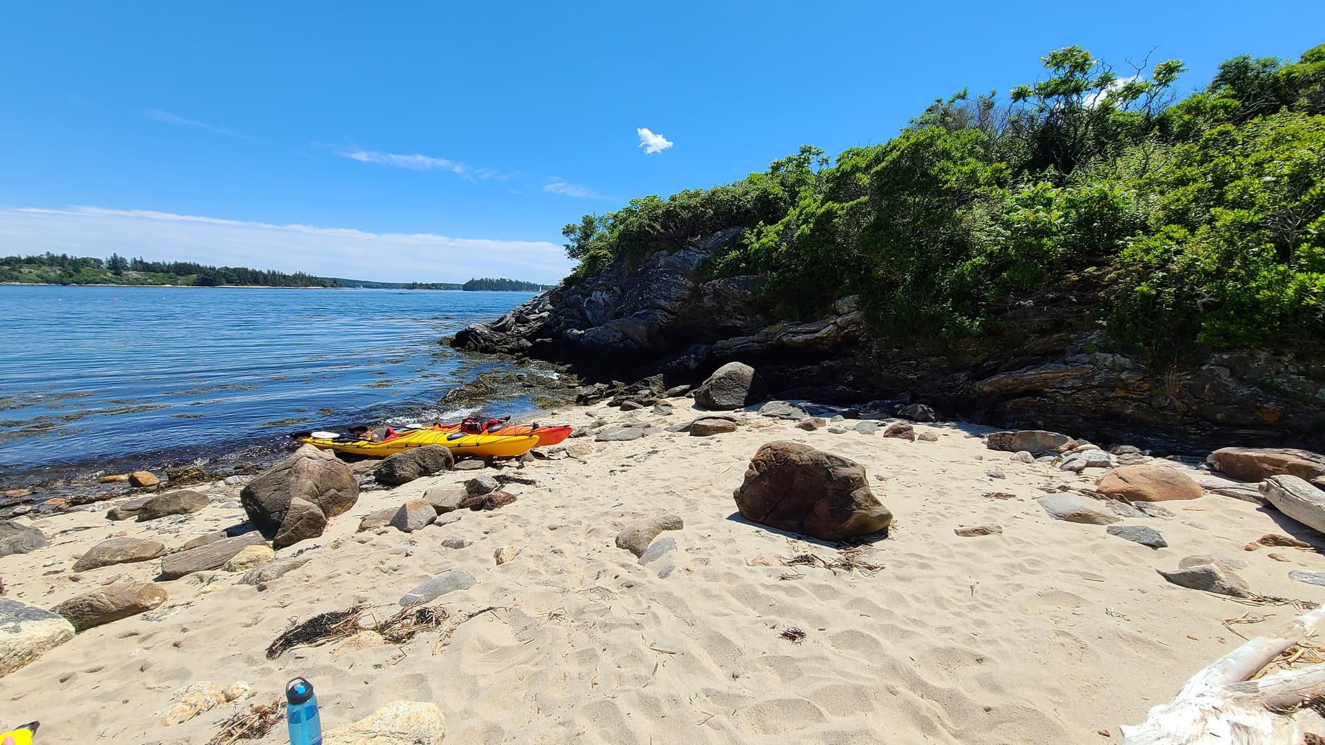
We went on Sunday. The weather was fantastic. Sunny, high 70’s, waves under 2 feet, and a gentle wind under 10 mph. We had the tides against us, but it wasn’t difficult to paddle against it. We didn’t go too far, about 8 miles round trip. We put in at Knickercane Island park, went down to Green Islands and back. This was my girlfriend’s second time in a kayak this year, the first on a small lake near here, and she hadn’t paddled since last September before that. She was having a lot of fun spotting the seals though, and playing in the boat wake when one would go by.
This was where we stopped for lunch, the small beach on the back side of Powderhorn island.
1 Like
Sounds like you had a perfect day. Sunday was a really beauty - I paddled out of Round Pond Maine that day. Another nice area but the parking fills up like many of the popular town landings.