Hello Paddlers. There is a group of 4 of us that will head to buffalo river in 2 weeks. We will arrive Thursday evening and plan on camping Thursday night somewhere(not sure where, would love some suggestions–we can camp an hour away if it’s a cool place or even cabin it if need be) and getting on the river Friday AM and cruising for 2 nights on the river. I am looking for help planning trip. Where should we launch? We wanted to launch upper and go about 24 miles to Ponca?? We want to get out and hike and do some rock climbing (we have ropes and gear) where are spots we can do that? Are there markers or places we need to keep our eyes out for anything? Is Eden falls around there? Where should we camp 1st night and 2nd night? Thanks for all suggestions!!
Some info
I am sure you will receive more info from Ozark paddlers like thebob and wildernesswebb who have more experience on the Buffalo than I. But here is a start.
The Upper Buffalo has the most fun water and in my mind the best scenery. Nothing you can't handle with boats reasonably loaded for an overnight if you have experience on moving water. Some class I and a class II (straightforward) depending on water levels. The middle and lower sections have less challenging water but all the scenery on the Buffalo is great.
I am not sure from your post if you are base camping or downriver camping.
If you want to do the Upper Buffalo, Steel Creek is the most beautiful campground in the world. It would also be a good base for Upper Buffalo day trips. There are others more centrally located, but I think the scenery at Steel Creek is worth the longer shuttles. I have used Steel Creek as a base camp for day trips between Ponca and Hasty.
If you are planning on downriver camping you should find places along the river for four of you to camp. Just be aware of rain and forecast rain in the area, especially further up the watershed. The Buffalo can come up very quickly so make sure you have an escape route from your campsite if it's needed.
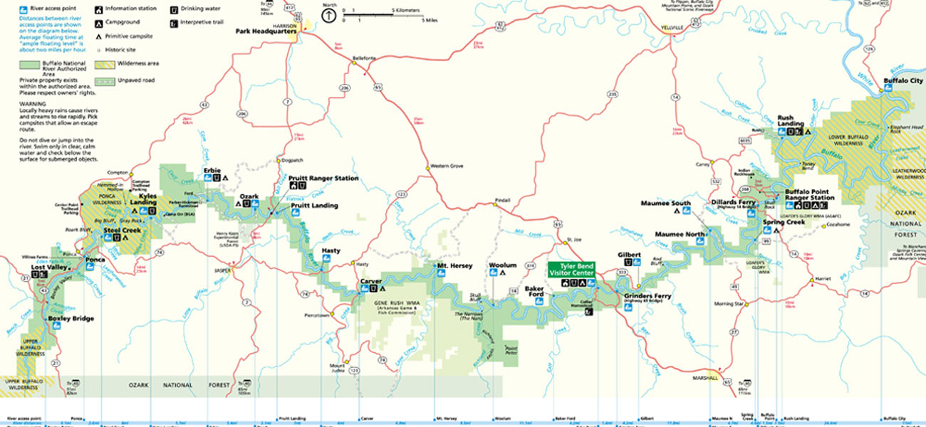
Ponca to Kyle's Landing is about 11 miles, Kyle's to Erbe is another 6 miles, Erbe to Pruitt is another 8 miles, and Pruitt to Hasty is another 7 miles. That would make a good two day trip of about 31 miles or do sections as day trips. You can cut it or extend it as you see fit.
I tried to send you a link to the NPS Buffalo River PDF map but it gave me a "404 Error - File or directory not found" page.
Send me a private email and I can send you an email with the NPS Buffalo River Map, and a mileage chart of the distances between landings as attachments.
Buffalo river
Vic. Thank you so much for the info!! I think we are wanting to maybe do a bit shorter distance trip so we can pull over and hike and climb. Like 20-24 miles. The camp ground you mentioned, is that where you would stay the night before we get on the water and put in there? Any places you recommend to pull over and hike and climb and explore. I hear there is a ghost town somewhere and caves?
Advice
If you go 24 miles "above" Ponca, that means you will be doing approximately 16 miles of the section of the Buffalo referred to as Hailstone, or The Hailstone.
Depending on water level, that section can be class II, class III, and possibly some class IV paddling.
If you go up there intending to paddle that whole 16 mile section; you had better have you game together!
I would not try it in any canoe, or kayak that was heavily loaded; nor would I try it in any boat that was not fully outfitted for whitewater. I would not try it in a recreational canoe or kayak. If anything happens to you, or to any of your paddling companions up there; I hope you have a good first aid kit, and an evacutaion plan. There will likely be nobody up there to assist you in any way, and it is highly unlikely that a cell phone will work up there.
If I were you, the highest I would go up on the Buffalo would be Ponca, and then paddle 24 miles downstream from there. That may be? what you intended to say? There is a canoe outfitter at Ponca that can assist you in getting your vehicles downstream to your takeout.I think their prices are reasonable. Your put in would be less than a half mile distance from that outfitters place of business.
The Buffalo is dependent on rain year round.
It is a beautiful river.
I will volunteer no rock climbing or caving suggestions, other than to say that you may be wise to do some research, to see if rockclimbing/caving is even allowed along the Buffalo. Refer to my warnings about first aid kit, evacuation plan, no help readily available, and no cell phone availability.
The last wanna be climber/caver I helped rescue broke his back, climbing in a cave with no helmet or belay system.
Vic has already given you the heads up about rapid water rises during heavy rain on the Buffalo. If heavy rain is a possibility; make sure you have an escape route.
Truthfully, it sounds to me like the activities you would like to do(rock climbing, caving, hiking), plus the paddling necessary to do approx. 24 miles of the river, could easily eat up the best part of 4 or 5 days.
Good luck,
BOB
Upper Buffalo
Well the first that you are doing right is picking a good time to come down here. Our rivers and creeks are primed. Any rains that we get the next month or two are going raise the levels quickly. Even if we didn’t get a drop of rain in the next two weeks the middle and lower sections of the Buff would still be floatable. A great source of river levels aside from AW is
http://www.ozarkpages.com/cgi-bin/stages.pl
This site was developed by a steep creeker and excellent boater, but his primary objective was/is whitewater. I’ve done many sections of rivers well below his recommendations, but it is still a great resource.
First off you are highly unlikely to do the Hailstone. It is a 14 mile run and you need to put on within ~12 hours of a heavy rain (min 2"). It is an all day paddle and REMOTE. Boxely to Ponca (II+) is a 6 mile float with a few sticky holes, it can usually be run up to a day or two after the Hailstone drops out. Ponca to Kyles is a day float that is currently still running after the rain we got last Saturday (3/15).
I’ll agree with the others that Steele Creek is a great drive up camping spot. Although, all of them on the Buffalo are. They each have their uniqueness to them. It is hard to pick a better backdrop then Roark Bluff at Steele Creek. Eden Falls and Eden Falls Cave are around 8 miles away. You can find them in Lost Valley, along with many other wonderful geologic features, and it is an ~2 mile hike one way. All caves on pubic land in the state of Arkansas are in a moratorium, i.e. closed with hefty fines if you are found in them. So don’t go in the cave, but don’t let that deter you from visiting Lost Valley.
Kyles Landing is another great camp site. It can have a class III shuttle after a heavy rain or snow. The gravel road from 74 to Kyles is steep and precipitous on the sides. Great hiking and bushwacking all around there. Right in the vicinity to the turnoff to Kyles is the turnoff to Horseshoe Canyon Ranch. I don’t climb, but know many who do and they mention that it has great routes.
http://horseshoecanyonduderanch.com/things-to-do/rock-climbing/
I’m not sure if there are any bolted routes within BNR.
I’m not a big fan of downriver camping this section on the gravel bars. It is too far up in the headwaters and most the gravel bars consist large cobbles, rocks, and boulders. Sure you can find a place for a tent or two, but nothing like the gravel bars downstream.
Enjoy,
kru
Hi Kru!
Welcome to that other paddling site! DKing, the ghost town is Rush, which is on the lower section of the river. It’s actually the last access before the Buffalo joins the White thirty-ish miles downstream. If you really want to float camp I’d suggest planning on extending your stay if you can, but I understand the limitations of time. We’re all slaves to the dreaded calendar. I’ll post two web sites that you’ll find invaluable for planning purposes. The first gives some basic info and most importantly provides in one place links to every gauge and a rule of thumb for what each one means with regard to floatability (is that a word?). The second is the Arkansas Canoe Club message board where you’ll find more collective knowledge about the Buffalo than exists anywhere. If the stars align you might even get your shuttle(s) arranged gratis. Enjoy!
http://www.troop142bsa.org/buffalo_national_river.htm
http://forums.arkansascanoeclub.com/
Thanks
Thank you all so much. And being new to this I did misspeak–we want to put in at Ponca and float about 20-24 miles from there and camping in the river from 8-10 mile marker on Friday and Saturday. I hope that makes more sense. Also are there any places in between Ponca and down river to get out of canoe, go into a store and get ice say for the 2nd day? I didn’t know if we would pass any campgrounds or depots along the river, this may get a good laugh. Sorry.
refer to this map
http://www.buffaloriver.com/uploads/buff-map-cc.jpg
If you put in at Ponca the Ozark access site is 21.7 river miles downstream, the Pruit Landing access is 23.8 miles, and the Hasty access is 30.8 miles. There are campgrounds at Ponca and Ozark and also at Steel Creek (2.6 miles below Ponca) and at the Kyles Landing area 10.6 miles below Ponca.
You can get ice at Ponca. Once you put on, I don’t think you can unless you have some means to drive to Jasper.
No depots
There isn’t anywhere on the upper section to resupply once you are on the river. The campgrounds just have a drop box to pay your fees. The bathrooms/water won’t be turned on until Memorial Day weekend.
If you have two vehicles then you could stage a car at Kyles and then hop in it and go to town (Ponca or Jasper) and then re-set shuttle from Kyles to Pruitt. These towns are small and selections are few. Most don’t even know that Ponca is a town. Jasper is a little larger. Keep in mind that Newton county (where you will be paddling) is dry as are a lot of counties in AR.
The easier solution is to learn how to conserve your ice. I can have cold beer on day four on the Buffalo in July. I have a large one that carries drinks, food, and ice, and a smaller one that I transfer my daily stuff in to. I only open the large color once in the evening to transfer all my stuff for the next day.
kru
Again. Thank you!!
If we put in at Ponca, is there a marker or specific spot you recommend to camp 1st night and 2nd?? We plan on Ponca to Pruitt. We would like a short paddle the last day to Pruitt. Do you think this is too much for 3 days? We want to start at 11am Friday and off on Sunday by noon. Should we go shorter or is this ok? Suggestions most welcome. Thanks again guys!!
Daily mileage
Daily distances are hard to suggest not knowing how much time you plan to devote to hiking, climbing, cooking and other non-paddling activities. It is quite possible to kill an entire morning cooking, cleaning up, breaking camp, and packing.
For most people, barring mishaps, it is relatively easy to cover 10-12 miles in an afternoon especially if there is helpful current, which there usually is on the upper Buffalo.
Be aware that the stretch from Ponca to Kyles has some Class II action on it. It is quite possible to dump there.
As for where to camp, if you want to use the designated campsites, an obvious option would be to go 10.6 miles the first day from Ponca to Kyles, then 11.1 miles the second day from Kyles to Ozark leaving a short paddle of just over 2 miles the last day to Pruit landing. There is drinking water available at Kyles and Ozark.
Of course, if you see a gravel bar or other location that beckons as a campsite you are free to use it. You should understand that the Buffalo is a natural flow river that can rise quickly with heavy rain, so if you camp on the river choose higher ground if rain is forecast, or at least be sure you can quickly retreat to higher ground with your boats and gear.
No glass containers are allowed on the Buffalo and if you encounter any rangers, they like to see you have a mesh garbage bag in the boat. See this site for additional rules and regulations:
http://www.nps.gov/buff/planyourvisit/river-rules.htm
BNR
Luv the Buff! Take lots of pictures and say “Hi” to the elk for me
Buy the map
Trails illustrated has a great map of the western half of the BNR. It is a great resource to have with you. I would say that Ponca is a class II put in, i've seen so many swims there. Lick Ford is another class II and worth scouting. Hell's Half Acre is the other class II just upstream of Grey Rock (on the map). It has two holes, standing waves, and must make moves. Of course any class I shoal can have a class V strainer in it.
Hemmed-In-Hollow is a hike I do every time I run that section. All the tributaries are worth exploring if you have time.
Do your own research on whether there will be water available at the locations PBlanc mentioned. Last fall the park said that it will close all campgrounds on BNR (in the winter) due to budget restraints. Enough of us raised hell and a compromise was made that they would leave them open for primitive camping only; i.e. no water, no restrooms, and no garbage collection. I haven't been there this winter so I can't say for sure what the situation is like.
Enjoy,
kru
Just caught this
Hey Duece Coop,
Still learning how to drive this forum, I just noticed your post. Thanks for the heads up.
water
Drinking water is still available at campsites which are still open, even though the campsites are limited service and the flush toilets are locked.