Can you estimate height of waves 5 miles distant?

Hello again, do you have any trick for estimating the wave height 5 miles out in the distance? If there is no boat/buoy out there as a reference, how would one measure the wave height ? Many times I have set out in 1ft waves at the shoreline only to later dissapear in troughs & abort the trip half way to my destination.

To better illustrate my question with these example pictures:
The wave height in the immediate foreshore is determined by both by sea state & by how shallow the bay is . Would it be possible to determine offshore wave height through visual means? thanks,
R

When I can see the horizon from shore and it looks like a hacksaw blade I figure 12 to 15 ft.

thats the sort of guideline i was looking for. but i ask how far out is the horizon? if its 20miles out, & my trip is 5 miles out, then how do i work out the wave height at 5 miles?

here is another photo
the immediate foreshore, the waves look around 3 or 4 ft, how heigh would you estimate them 5 miles out? thx

Some say:
For an observer on the ground with eye level at h = 5 ft 7 in ( 1.70 m ), the horizon is at a distance of 2.9 miles ( 4.7 km ). For an observer standing on a hill or tower 100 feet ( 30 m ) in height, the horizon is at a distance of 12.2 miles ( 19.6 km ).

As I gaze out across the river I’m amazed you can see detail past the 1 mile markers I see. Five miles…there’s a judgement call.

I found this summary which may help a little.

https://oceanservice.noaa.gov/education/kits/currents/03coastal1.html

It says that the shoreline tends to make waves smaller since “different parts of the wave encounter resistance at different times”. To me that suggests that the effect should be predictable in a particular location when the wind is always blowing from the same direction…so if you typically have wind blowing from offshore and 3 foot waves near shore and 5 foot waves far offshore then that may happen every time. It also suggests that you should always expect waves to be bigger offshore.

Windy.com has pretty good resolution so you could look at it and see if you might expect increased wind speeds 5 miles away. Wind speeds often pick up from morning to afternoon so that may have an impact on what you are experiencing.

Or you could get a drone and just go look.

When I first read this I thought this was question was a bad joke.

Short answer. No.

Trying to come up with a helpful answer …

If you are serious I would spend some time getting informed about what wave/weather prediction services are where you paddle. In the US on the west coast and Hawaii the Coastal Data Information Program webpages on the internet give you the ability to check wave heights at buoys all over the US coastline. You can know wave height, average period, peak period and water temps for a fair number of locations all over the coast. There are also many good sites for wind predictions. The NOAA and NWS forecasts for local areas will tell you swell heights and predicted winds where you intend to paddle.

Similar services exist on the east coast and in the UK.

As stated above you are going to have stand on a high bluff, hill or similar to see 5 miles or 20 miles out to sea. What you really want to be concerned about when paddling a kayak is breaking wave height. If you look out and only see white water very close to shore , waves are not likely to be an issue, if you see white caps, you know you are going to have good sized wind waves, and they require skill and skill to paddle in the wind. If you look out and you see several hundred yards of foamy white water the breaking waves are well overhead and it would be foolish to paddle out alone at your skill level.

Best advice is to paddle with experienced paddlers until you get some better moving water skills.

1 Like

From an intellectual level you sort of can estimate wave height from a distance though 5 miles is quite a tall order, a few thousand yards tops is more like it. Buy a pair of binoculars with a reticle. Learn the conversion of the reticle and measure it compared to a known object’s height or size then compare it to everything else around to measure height.

For example an optic with a reticle that measures in minutes of angle or “MOA” equals 1 inch at 100 yards. So at 1000 yards something that is 1 MOA large on the reticle will be 10 inches in size. An average height human being might be 68-70 inches tall so if your reticle shows that human to be 7 minutes of angle tall then you know that an approximate distance to that human is about 1000 yards since that human would be 70MOA tall (or 70 inches tall) at 100 yards.

For entertainment purposes this is a lot of fun but you always have to rely on comparing to something of known size (or distance).

That said I would rely on a weather forecast. Me if any wind or waves are anticipated I just stay out of the ocean or go flatwater but I am quite timid and happy to leave my skills languishing. Paddling is fun but why risk it? I think most people would be better served by not taking risks; it’s all fun and games until someone goes missing.

1 Like

I ditto Tom about the Windy app. It shows more than just wind - it has an option to look at swells and waves. You don’t need to estimate; it’s pretty accurate for the most part. A marine forecast on a VHF radio can also be helpful in trip planning.

1 Like

What body of water are you on, specifically?

Can you estimate the height of waves 5 miles distant. No. You cannot see that far with sufficient visual acuity, And the horizon in all three of your pictures is about 3 miles or so. Also, waves stand in the way of seeing waves, you are looking at only the tops. What you can do to guesstimate…

Serrate horizon, don’t even think about going out.
Local knowledge. Every location is filled with unknown common shoreline shapes, wind direction, bottom surface shapes, there is zero substitute for local knowledge.
Waves need depth to exist. ALWAYS the waves farther out, deeper water, will be larger. Total waves heights approaching the shore the need 10 times the depth vs the height. Look at your second picture. I see three and perhaps four breaking lines out there, and I see nominal 1 to 2 foot waves breaking at the shore. I also see pretty much just green water at the horizon. My guess based upon years of experience. A developed sea (the waves are not growing) and so if the ones at my feet are 1 to 2, the next line out is thew 2 to 4, and the third line breaking is the 4 to 6 line. Offshore, I would figure rollers, non-breaking 4 to 6 foot waves, maybe plus a bit.
The fourth photo, white dots all the way out, a developing sea, waves are growing, each white cap is a small breaker, do not go out,You do not know how large the waves will develop to.
Wind speed vs wave height. This can be deceptive. Waves can travel hundreds of miles, so the winds here, and now, may simply be laid atop, or across the old long distance waves, rollers, sea swells.
But, 20 kts sustained will produce a real 3 foot sea + or - depending upon a wealth of factors, length of time its been blowing from that direction, fetch, etc. Take kts, divide by something between 1/5th or 1/7th and you have a ball park for height in feet, Divide by 5 you get 4 footers, divide by 7 and you get 3 footers… AND ALWAYS understand waves are measured by their low mean average. Low Mean Average means, one in ten will be 25% larger, and one in a hundred will be 50% larger. So on a 4 footer day, there are a few 6 footers out there. On a 12 to 15 meter sea state (I have personally seen this once on Lake Huron), there are 60 to 70 foot waves out there. One month ago the buoy two miles off Port aux Basque recorded a 30 meter sea, a 100 footer. 2 miles out.

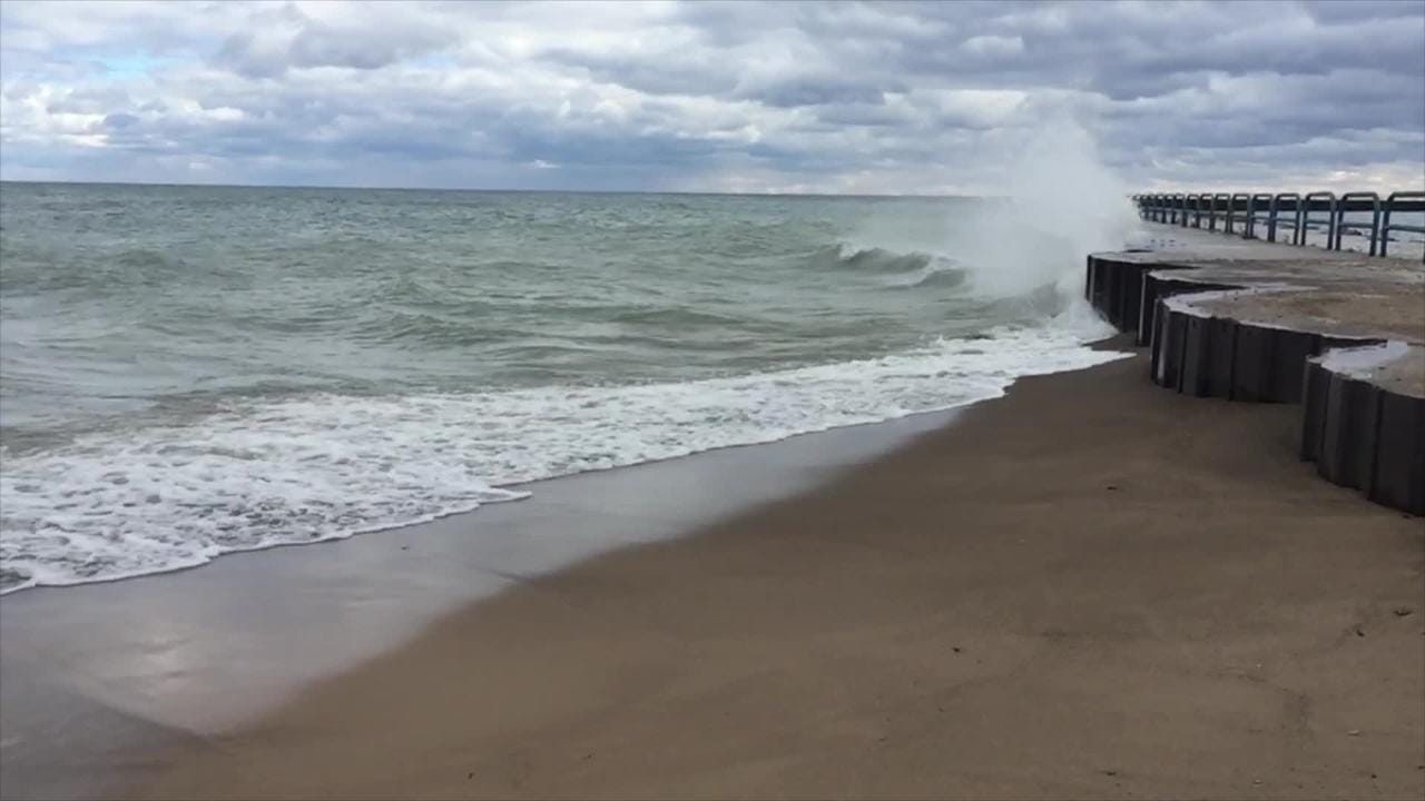
Your first photo shows a wind direction change, waves coming from one direct and spray blowing in another direct. That was likely at a point that sticks out into the body of water, the waves trying to turn the corner, In either case, Don’t go out. The polite term is ‘a confused sea state’.
Second photo, if you do not mind round shoulder 6 footers, I’d go our
Third photo cannot tell, Local knowledge required.
Fourth photo If I knew the area and I wanted a rip snorting day, I might go out. But it could get ugly if the wind maintains or gets higher.

So, the recap, No you cannot estimate the wave height 5 miles out. And from my own experience, imagine for a moment 1491, pre- Columbus, walking the ‘wilderness’ that only our native Americans saw, walked. Once you are 2 miles out, you ARE in wilderness every bit equal to that pre-columbian wilderness. There is a rouge wave, there is a great white under you, a grizzly just walked into camp, wilderness. Just two miles out. It ain’t nothin’ to fool with. You have to know what you are doing.

3 Likes

Something to think about and remember…
Two miles can be a long way when things start going south…

From my experience, whatever the waves look like from shore, I estimate they are going to be double, or tripple that.

Really, i would argue height by itself is not that important or relevant without additional context. 8 foot 16 second waves feel like flat water because they’re shallow. 2 foot 3-4 second waves feel like a bull ride. The steepness of the wave and number of wave directions has a much more significant effect on the feel of tippiness than simple size may imply. The devil’s brew for messy conditions to me is -

  • 2 or more long period swell directions, separated by more than 30*
  • 1 or more short period wind wave directions, not in line with any long period swell direction
  • Reflected waves coming off a cliff or sea wall
    In conditions like that, the waves come from basically every direction and even if they are small (as in <3’) it can be very tippy feeling although their overall size is small-ish.

Also consider that your head is less than 3’ above water level. I am over 6’ tall and measure about 32" from butt to eyes when seated flat. That means it takes less than a 3’ wave to obscure the horizon. A lot of people say ‘10’ waves!!!’ but really I bet they are much smaller in many cases. Use the horizon line as a reference. Can you see it sitting in your boat? if so, the waves are <3’.

Anyways, just saying consider steepness (height:period ratio), # of swell directions, and other complicating factors more than absolute wave height.

I use the closest CDIP buoy, other NOAA buoy’s, and Windy.com to judge current conditions. Although they’re not spot-on, they will give a decent judge of the sea state miles out. How the shore waves translate to open ocean waves depends a lot on period as well.

Since your eye can’t tell the difference between three miles and five miles when looking over open water and since at that distance large differences look small I’m going to say not a chance.
To break it down to simple math, the difference between a 10’ wave and a 50’ wave at that distance is 0°04’13" of angle. That is a very small and mostly unperceivable to most peoples eyes. To make it worse, if you misjudge the distance those same bumps on the water that difference in appearance that is a 40’ difference in wave size at 5 miles is 24’ difference at three miles. You would have six and thirty foot waves.
Hell I have a hard enough time judging the size of a bear at 250 yards. A wave at 5 miles…… best you can say is it looks rough out there.

I can’t estimate with any accuracy pretty much any distance from shore, unless the waves are going past something that I can use to estimate the size.

Even at the breaks or play spots I know well, when I first get there I need to spend some time watching waves before I can start estimating size (and also figure out what that day’s pattern and wave size are like).

Only after I start seeing signs that I can use can I start figuring out wave sizes. How large a wave is when it passes an offshore rock, when boomers form (and when they don’t), how far out the wave breaks as it approaches the shore, size of the wave as it passes a surfer/boat, etc.

If I was in an area without significant tides (like the Great Lakes), it may be possible to estimate just by looking at first waves and remembering how it was in the past. But in areas where the water depth changes during the day, I need to view for a while.

I estimate t wave/swell height by looking up the surf report online.

2 Likes

Some years ago now I took a limnology course, so this info (taken from the text for that class) is intended for use on lakes but it might be of some use to you if the area you are intending to paddle is an isolated bay or, of course, a lake. It is probably better suited to BWCA paddlers and such, but might help with some “ball park guesstimations” for you in some situations. It is based on the “fetch” of the body of water, which is the distance (in km) over which the wind can blow unobstructed when it is from direction from which the wind is blowing. (So you’d need a map and accurate wind direction info.) In other words, waves on a long narrow body of water can get bigger when the wind is blowing along the length of the lake than when it is blowing across its narrow width - which is intuitive. Irregular shorelines and diagonal winds are the norm though, and complicate matters a bit. It also assumes that the wind has been blowing from that direction for long enough so that a stable equilibrium has been established. No storm surge or seiche conditions are considered in this formula.
The formula given is: Hmax= 0.332F^0.5 (Hmax in meters: F is fetch in km)
Wave length max is ~20Hmax.
Surface gravity waves will break when the water depth is less than about half the wave length.

Hope this is of some use to somebody - and sorry for the slow response. I’ve been out of town and without computer access.

thanks to all contributers, really good stuff