I’ll be in Charleston for a couple of days in Feb. and am looking for 1/2 to 3/4-day trip recommendations. Will be in unfamiliar territory and most likely solo (unless my brother-in-law gets a leave from Iraq - not likely since he just headed back in the last day or so). With that in mind, I’m looking for a fairly easy trip or good launch sites and any hazard areas that I should avoid. Thanks in advance for the info. Laura
Paddle the harbor from Sunrise Park
on James Island. Paddle to Castle Pinckney, then the Battery, then back to the island. You can see all 3 places from all 3 places. It is a leisurely 3-4 hour paddle.
Or, cross the Cooper River and paddle around the WW2 ships at Patriot’s Point. You can launch Shem Creek in Mt. Pleasant or a public landing north of the Cooper River bridge. The natives will have to direct you to those places.
Just watch the currents
Charleston has some strong currents. Watch crossing some of the rivers feeding into the harbor and around the islands. There are a lot of paddlers in the area.
Here are some URLs for paddling in the area
http://www.lowcountrypaddlers.homestead.com/LCPA.html (Charleston Kayak group)
http://www.semanchuk.com/TripReports/
http://www.canoesc.com/
http://www.coastalexpeditions.com/
isle of palms
I paid $5. to park in marina on north side of isle of palms and paddled coastal waterway. Very safe on a windy day but please ask locals about bucking the tidal surge as you go out or back in. Safest to paddle south to bridge and back to marina. The county park beach was closed. Charleston has lots of towaway zones. Staying at shem creek inn , you could get your seafood fix at shem creek bar and grill or rb’s. Maybe they would let you park. You should drive out to battery park. We toured yorktown and a destroyer. Lots to see but please do your homework on tidal flows. A strong west wind and a capsize could put you a long ways out.
The Holy City
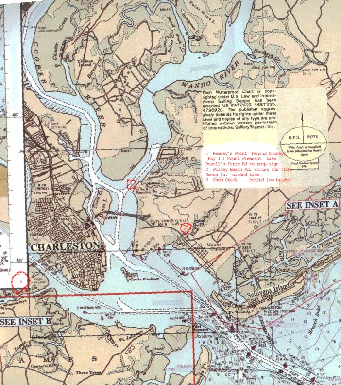
Couple of boat landings are identified on the chart:
http://photos.imageevent.com/dgb8363/charleston01///charleston.jpg
Sunset Park over on James Is. (turn left off Folly Rd. at the water tower, left again just before you get to Fort Johnson) is a bit tough getting boats or boards to the water, a riprap bank to negotiate, and at low tide some REALLY soft silt to slog through. Shem Creek is pretty good, current isn’t as bad there as some places. Remley point is a ways back up the river, and you want to go out with the tide and in with the tide if you use it, same with the landing on the ICW on folly beach rd.
The Wando River (upstream from Remley Point ldg) is a neat place to explore, Cooper River, also.
There is a small parking lot at the north end of Sullivan’s Is. right next to the water, good place to launch, but, as usual, watch out for the currents. My favorite place to launch (the Hobie Cat) is at the South end of Sullivan’s Is., just at the far edge of Fort Moultrie (site of the original Fort Moultrie - that’s where the palmetto tree/crescent moon logo comes from, the revolutionary war Fort Moultrie the British Navy shot up all night but couldn’t blast to pieces because it was constructed of palmetto trees, which were resilent enough to just absorb the impact of the cannon balls). Not much parking space, but in the winter should not be overcrowded. Again, current.
I have never launched there, but there used to be a small sandbar at the north end of The Battery, downtown. Don’t know if its there at high tide.
The south side of the Cosgrove Avenue (off I26) Bridge has a good launch site, make sure you park above high tide. This is on the Ashley River, good place to go either downtown or up the Ashley, which I haven’t done yet.
Thanks Guys!
I’ll get the maps out and buy a chart after work tonight to check out your recommendations. Looking forward to it. It’s -3 degrees F right now and the wind is howling, so who knows how cold it feels. Cold enough that the excavators and dozers won’t start and if they do, they won’t stay running. I told my crews to take the afternoon off. The harbor is pretty though. Sea smoke blowing across waves that are covered with white caps - makes me shiver every time I see it. Wouldn’t it be fun to paddle through sea smoke? If only it were 30-degrees warmer! But then we wouldn’t have sea smoke - can’t win. Took some photos with an SLR camera - will post them when developed.
Thanks for the info. Laura
Sedna - That whole area is beautiful
but if I took a paddle trip there my first place to go would be Patriots Point and paddle around
the Aircraft carrier, etc… That would be awesome. I took a boat ride there a couple years ago, so that is why I would got there first.
But it is up to you of course. Have fun.
I also enjoyed walking around the old part of town and Battery Park. Really nice.
folly beach
on the south side of course is way cool, try the med deli on the way out, ask some locals for directions. i like to camp at james island county park, they have a great climbing wall. there is also paddling in the smallish but pretty lake and access to the icw from a floating dock if you can portage. the back side of folly is beautiful and protected, the beach is an east coast surfing mecca. my favorite motel is the holiday motel, very quaint. ask for the room on the north end. norwegian wood with mirrors : )