
Heavy fog to low overcast, Winds calm increasing to W @ 15 knots, Seas calm to swells to 1.5 meter with 2-foot windwaves, Seas rippled
As hard as it was to be facing another day of paddling in fog, I knew that this was my one weather window to cross Queen Charlotte Strait for many days to come and I was ready to get back home. The fog seemed even heavier than it had been for the past two days and those two days had been decidedly un-fun. After thirteen days without rest and two days of pressing hard to get here to make this crossing I was spent and had to give myself a pep talk in order to leave the beach. The wind and seas had been up keeping pleasure cruisers at anchor but, as forecasted, conditions had subsided for 24 hours and were expected to return in the afternoon. Fog or no fog it was time to go.
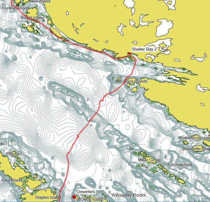
Everyone knows that the shortest distance between two points is a straight line so we tend to lay out our courses between those points using a series of straight lines and shallow angles. In this case my points were Shelter Bay and Bear Cove which involved a 16 NM whiteout crossing of Queen Charlotte Strait.
My course consisted of three primary legs with negligible course changes but three significant intermediate crossings. The first approximately 5.3 NM from Shelter Bay to the Deserter Group, then 2.5-ish NM from The Deserters to Bell Island and finally 3.5 NM angling across Goletas Channel to Duval Point.
I planned for the ebb to be changing to flood about midway through the first leg and figured that it should about equal out so I didn’t change my course legs. If the fog didn’t clear I would just adjust headings to achieve my desired course-made-good. My GPS was set to display speed, course-to-waypoint and heading, however, I would take my heading from the deck compass.
That first 5.3 NM to the Deserters crosses a major shipping lane and is an enormous tidal passage. I would be making that crossing in a complete whiteout and thanks to the Raven that destroyed my antennae I could receive but couldn’t send to alert shipping traffic of my whereabouts. At 7:30 AM I left for Port Hardy on a heading of 180 degrees.

Things got pretty strange from the very beginning as I struggled to maintain my heading and reconcile it with the constantly changing course. I can hold my focus on the deck compass and maintain a heading for hours but when I look down at my GPS for the speed and course I get dizzy and it takes a bit for my eyes dial it in and longer to digest the information. In the meantime, my heading changes, correct, repeat, repeat, repeat. I was pretty certain that my course was falling well short of being a straight line.
Several times I heard powered craft making the same crossing. Only once did the fog and their close proximity allow me to actually see a boat as it motored past unaware of my presence. The rest of the time I listened carefully and tried to located them by sound.
The leg from Shelter Bay to the Deserters should have taken a little under 2 hours. When my time en route passed the 3-hour mark it was the second clue that my course was far from ideal. At that point I gave up worrying about my course and just paddled a 180-degree heading knowing that whatever the current did with me I would eventually bump into a shoreline and figure out a course correction at that point.
Gradually the dark grey lightened and my desired waypoint emerged in the distance. I was on track! I couldn’t believe it! I didn’t have to stare at my compass for a while! I couldn’t wait to be done and give my mind and body a rest from paddling.

The Deserters
__
It was another 4 hours from the Deserters to Port Hardy. During that time the fog lifted to form an overcast and then dissipated altogether giving way to a bright sunny day. The westward flowing ebb that had confounded me gave way to the flood and a west wind began to build in Goletas Channel providing a bit of a nudge on the final push.
It wasn’t until I downloaded my GPS track that I realized how much the current and zero visibility had messed with me. I had turned my 16 NM course into a 17.1 NM journey.


Jon
https://3meterswell.blogspot.com__