Hello everyone. Got a question about GPS devices. Just bought a 13ft Riot Enduro to take paddling, mostly around the Chesapeake bay, but also the South Carolina marshes when I’m down there (probably next summer). I’ve found that having my phone GPS handy is very helpful, mostly for finding my way back to my put-in spot and avoiding long detours from turning into the wrong cove or inlet along the coast. I’d like a GPS unit for day tripping, not far from shore. Is there any sense in picking up a dedicated GPS unit like the Garmin GPSMAP 78SC, which can be had for about $200 including detailed coastal charts, or am I better off to just ruggedize my phone with a waterproof case and make do with Google maps, or even a third party marine mapping app? I won’t be paddling out of sight of land.
Aside from whether the third party apps are sufficient, your iphone won’t have sufficient battery to run a mapping app all day.
A dedicated GPS unit will give you the peace of mind of having a robust battery. And of having a backup (your phone) in case it fails.
Also, by the way, you should also budget for a waterproof portable VHF radio with DSC. Again…your phone should not be your primary method of signalling for help.
Just my .02
Any recommendations? The GPSMAP 78SC floats, which is a nice bonus, but the screen is tiny. The Gpsmap86Sc also floats has a larger screen, but is a bit pricey. Also, any recommendations on the radio?
@dsf3g Welcome to the forums, by the way!
There’s not a tremendous amount of conversation here about GPS…if you do a search you will see some commentary, some current, some a bit dated. You might want to go to a marine retailer, like West Marine or similar, and ask their advice for local usage.
With regard to the radio, there was a recent thread on this, here.
I’m just a bit embarrassed to admit this…but 100% of my paddling over the past four years has been on our local kettle pond. With a 2.5 mile circumference, it’s great for a workout, and at the right time, great for watching wildlife. So…I haven’t really needed a GPS or radio. I do have an ICOM M24, the basic waterproof VHF in the line, which I bought on the expectation that at some point I’ll venture elsewhere with a friend or two… 
If iPhones are in your electronic arsenal, the Bad Elf GPS Pro has been part of my navigation kit for years. The battery has never run low. It displays through my iPad or iPhone (Bluetooth connection).
Using another model: GPS for Lightening, at first, wasn’t convenient in canoe-wet environments. They let me trade-up to a GPS Pro. It stows in a dry bag while connecting to an iPhone (in a waterproof case) attached to a PFD.
Given how long Garmin GPSs tend to last, I’d be tempted to go with the larger screen. I have a 20 year old Garmin GPS III+ that is still working although some of the screen pixels are starting to fail. I now use a much newer but discontinued GPSmap 76CSx as my main GPS and carry the III+ as a backup.
I always carry my GPSs in a waterproof soft case because I am nearly always in salt water and seals eventually fail. A GPS in a waterproof case like a cell phone case works just fine.
A GPS that is waterproof and floats to begin with has obvious advantages over a cell phone, plus a longer battery life. There are many areas on the water where you might not have cell phone coverage. If your phone does not have a dedicated GPS receiver, them you lose your map along with your ability to communicate. The same is true if your phone battery dies or gets damaged by exposure to water.
In addition to a GPS I always carry a VHF radio in addition to a GPS. I generally don’t carry a cell phone as I rarely paddle where there is no USCG VHF coverage and I don.t value always being tied to an electronic leash.
Some of the newest GPSs have satellite communications built in, but this requires a subscription and they are very expensive. No one that I know of has come out with a combined cell phone and VHF yet. There are devices that combine GPS and VHF capability, but the screens are often smaller than a dedicated GPS.
Pretty much any Garmin handheld will be waterproof, and you can add whatever maps you want, so you don’t necessarily need to limit yourself to the “marine” handdhelds. (*Unless you’re specifically interested in the Marine Navigation charts; those aren’t readily available for free that I can find, so it might be cheaper to buy a marine handheld that already has that basemap. If you don’t care about bathymetric contours, then other handhelds may work just as well for you.)
I’ve personally owned the GPSMAP 60CSx, the GPSMAP 64s, and now the 66i. I use them for hiking, rock climbing, and paddling. I’m in the midwest, though, so I’ve never needed actual marine charts; just topos, which can be downloaded for free.
I personally like the GPSMAP devices due to the hard button functionality (works better when wet or with gloves than touch-screen devices.) The models I’ve owned don’t float, so I have a floating lanyard that I attach, and I also clip the device to the deck rigging with a short sling.
I’ve used Garmins, but I use an app on my Android called Geotracker and am happy with it. Last I looked there were half a dozen more apps with the same name; its free from Ilya Bogdanovich. https://play.google.com/store/apps/details?id=com.ilyabogdanovich.geotracker&hl=en_US
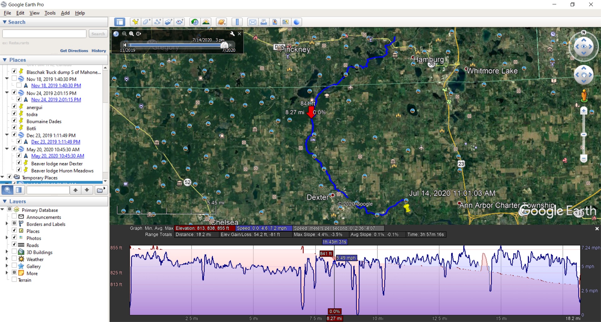
It uses zero battery if you turn it off during your trip. For tracking it just accesses your phone’s location log. Playing with it in airplane mode it appears to store at least some of the map on your phone. I like the app because you can export your trip to a KML file, which on my laptop opens Google Earth and shows me my route there. Google Earth has a nice speed graph showing you how fast you were going at what point on the map.
Let me start by saying that a compass and map are the safest way to navigate. Batteries never fail and no menus to mess with. Another phone issue, at least for me, is that I spend quite a bit of time where there isn’t any cell signal, and I like to leave the phone home on weekends.
That being said, I’ve been looking for a good one, not so much for navigation although I would probably mark some spots worth returning to, but I’m looking for something that does a good job of just tracking distance paddled, average speed and a bonus of the highest speed hit.
I’m looking at it more for an honest training tool.
I want to simply track these things so I can make realistic travel planning and to track so I can improve. A lot easier to bust out a few more miles if I’m looking at my total, and I don’t want to use my phone.
After posting my reply above, I did a bit of searching out of curiosity, and it appears that openseamap.org has a free nautical chart that works with Garmin GPS units. (Again, this could potentially olpen up your list of options oustside of just the marine-focused units.)
https://wiki.openstreetmap.org/wiki/OpenSeaMap_and_Garmin_nautical_chart_plotter
I just looked at Bad Elf GPS Pro, it just seems to be a Bluetooth GPS device, why have that when phones have built in GPS now. I am not sure if you are worried about your phone battery going out on you, why this device makes any difference, you are still using your phone. Or did I totally miss the idea on their website ?
GPS, used constantly will run down a cell phone’s battery pretty quickly. In addition few cell phones offer a track back function. Knowing a straight line path back to a launch is pretty useless in many cases. It’s not like turn by turn directions on a road.
When paddling in areas I am not familiar with I will download a local chart as well as carry a compass, This is addition to carrying a couple of GPSs as some of my solo day trips are 25 to 35 miles.
Can I ask what GPS device you carry, and how you use them?
mikeyr, a brief answer (because my technical knowledge about these matters is very limited):
The Bad Elf, and Garmins, for example, are refined designs, very dependable positioning devices while using satellite reception.
Cellphones may or may not depend on satellites, or satellites ‘as much’, using towers (or blending towers and satellites).
I like relying on devices that offer dependable accuracy, perform data logging functions, route storage capacity, compatibility with other navigation programs (and/or apps), long battery life, and compact storage.
Hope this answer is helpful. (I have a Garmin product attached to an off-road trail bicycle that records fitness data while it also connects wirelessly to Google maps displayed on a cell phone).
The idea is that cellphones being used for data logging, tracking, map viewing etc etc burn through their batteries quickly.
If I needed to use a phone and nothing else, a plug in rechargeable spare power supply would be in my kit.
And nothing beats the reliability of an appropriate paper (or waterproof plastic) map, and a whisky compass (both coupled to a human brain) for keeping track of where we are and for deciding where to go next.

I am with some of the older folks above. Get/download paper charts (you can plasticize them) and carry a compass. Learn to keep track of time, headings and landmarks visually. There is nothing in your original request that cannot be solved that way and such habits can save your life.
Not saying that you will never want a GPS unit, I carry one in my day hatch in Maine when I have gone further out as backup if a fog bank moves in. But I also mostly paddle the same area, it has been 10 or so years since the Garmin unit came out of the hatch and got turned on.
I’ll echo everyone’s advice about printed maps/charts and compasses being the first tools to know and use. I carry two compasses and a printed map/chart in addition to everything below when it really matters. Three if the boat has one mounted. That said, in many places the vegetation and/or geography can limit their usefulness.
I used to carry a dedicated GPS but now I just carry multiple phones. I reserve my most modern up-to-date phone, kept safely in a dry bag inside hatch. The older one(s) I’ve retired from active duty or received for free from others are treated with less care. There’s nothing wrong with the GPS accuracy of a PROPERLY CONFIGURED smart phone. There is, however, much ignorance about the technology and how it works. The variety of OFFLINE maps available for phones has been much better than the overpriced ones available for specific devices. Relying on any app that uses online maps with a data connection for NAVIGATION is reckless and dangerous. Verify that everything works with your “airplane mode” turned on before heading out with it for navigation.
Never forget that maps and images are dated and seasonal. Water levels change over time and with tides. Vegetation can vary significantly and beavers work quickly.
Battery life is absolutely an issue. A cheap “power bank” or two can supplement the built-in battery. Better yet, you don’t need a full track log if you’re just trying to find a way through a difficult patch. Leave it off, then only turn it on to figure out where you are and plan where to go. If this isn’t sufficient then you’re doing something wrong.
ALWAYS have a backup plan or two. Where is civilization/help? Which direction will you travel when your phone dies or gets lost in the deep? What will you do when your PAPER MAP blows away over an inaccessible cliff?
Oregon 450 Old but sufficient. I would way rather have buttons than a touch screen which is over sensitive but not that much of an issue ; more a frustration
Always backed up with paper maps to see the big picture
Up in Northern Ontario and Northern Maine the phone does not work. You can look at your blue dot on a white screen. Useless. There is no cell coverage. Actually at home it does not work well at all either again we are in a dead spot.
When on the road and using GPS the app really drains the battery fast on the phone…
For paddling I like the GPS handy for when as Celia mentioned the visibility goes away and there is nothing to pilot off of and also for the small picture as in trying to find the chickee buried in a mangrove that looks just like all the other mangroves for a hundred miles.
You highlight well the lack of understanding the difference between online and offline maps.
Nothing I rely on requires cellular network coverage.
So educate me instead of being snarky.
This would have been way more useful than your idiotic comment
Have a coffee and try again. Nothing I wrote was snarky or personally directed, unlike your response.