The Tahe wasn’t at all what I wanted, but it was really cheap and I figured it would be okay until I found something better.
It is shorter, wider, flatter, and blunter than the Solstice; but the cockpit is nice and big.
I took it out today with a GPS and recorded my speed, the same as I did with the Solstice.
The Tahe is significantly faster than the Solstice?!
Shouldn’t it be significantly slower?
(No, the wind was light and I averaged going north and south …)
I have tested several kayaks with the same GPS over the years and up to now they have all done about what I expected.
Are you talking max speed or average speed? Max speed is limited by hull speed, which is mostly based on waterline length. Average speed is more based on wetted surface and shape of surface. A boat with a higher max speed is not necessarily more efficient through water at lower speeds.
The Tahe appears to have less rocker and a plumb bow and stern. So even though its overall length is 1.5 feet less, it may actually have similar (or even greater) waterline lengths.
The CD is made to carry a lot - look at its max capacity of 400 lbs. Many of CD’s larger boats (perhaps this one included) have a reputation of not performing all that well when unloaded. Even if you are 200# plus, that may not be enough to get the CD to really sit in the water and perform the way it is supposed to.
Of course, you need to isolate any variances away from the boat, such as your condition, wind, current, etc. Sounds like you have done some toward this, but hard to fully get these out.
That is true; the bow and stern of the CD are out of the water for a bit, while the Tahe is entirely in the water.
The GPS measures current and maximum speed. Since I can’t look at it while paddling, I rely on the maximum speed.
My “routine” is to paddle very slowly and note the speed, paddle a normal slow rate, paddle a normal fast rate, and then as hard as I can go. Then comparing the 4 maximum speeds for each of the 4 paddling rates.
The system is not perfect, but doing the same way each time should give meaningful results.
I weigh 185 and had nothing but the paddle; so maybe I was too light for the CD?
The actual figures are below. The Zoar is a 14’ 25" wide poly Zoar Sport.
Zoar Solstice Tahe
Minimum 2.6 3.1 3.4
Slow 3.1 3.8 4.5
Fast 3.9 4.3 5.2
Maximum 5.1 6.0 6.3
Can’t seem to format this properly, but you get the idea
DONT count on maximum speed from any gps. they sometimes jump around a bit causing a false max speed reading. Take some foam and get it propped up under the bungee cord so you can read the gps while paddling. Then you will see your real speed. I have a suction cup mount on my setup. Then set GPS so it display mph in large numbers so easy to ready while paddling full out.
I’d think the max speed captured by our GPS may be the least reliable data it’s collecting. It’s an instantaneous single data point capture and as such it’s subject to quite a bit of potential error. As an example, I’m checking battery life in my Garmin Etrex20 right now. I put in a set of freshly charged batteries and start it up. I then sit it in the window until the batteries are exhausted and the unit shuts off. I then restart it and check the trip log to see how many hours the “trip” took. It isn’t unusual for the max speed to be 1 or 2 mph and yet the unit just sat on the window sill the entire time it was on. The average speed is zero. I hike with the unit often and the max speed is usually reported at around 5mph. I don’t hike that fast, nor do I run. The unit may have grabbed a point when I was turning around, or taking off my pack, or unclipping it from my pack to check time/miles…etc… Over a 9 mile hike the unit collects about 1200 data points and just a couple at “max speed”. Data points close to that max speed (in time) are no where near the max.
I’m surprised your GPS doesn’t report an average speed. If you can access the gpx file it creates(assuming it creates) you can work it up to get an average speed. There’s a number of software packages that can do this…I use Garmin Basecamp(free). Online…maybe GPS Visualizer has something…
To draw any kind of conclusions like you’re making you need to use averaged data from each out & back run. (I’m a retired chemist & analyst…trust me on the numbers part.) Consider your average shop vac that’s advertised as creating “5 peak-hp”. There is no world where 120V will create 5hp nominal. For that first few milliseconds after you turn it on…maybe, but not for long. That “5hp” rating is meaningless with respect to how the vacuum performs.
Others are right about the maximum speed being the figure that has a fair chance of being wrong. Doesn’t your GPS record average speed as well? And couldn’t you pause in your paddling, just momentarily, and see how the average speed is shaping up as you travel? I have darned near the cheapest GPS ever made, with the fewest bells and whistles of almost any that was ever made, and it records average speed.
That said, I see nothing in your post about your age, size, strength, or fitness level, and you didn’t list your speed data either, so it’s worth noting that I have seen cases where a small person who’s not particularly strong actually did have a higher maximum speed in a short, chunky boat than in a long, lean boat. Sure, the short chunky boat could never go as fast as the long lean boat when paddled by most people, but for someone who’s output power is limited, the fact that the shorter, chunky boat moves more easily at moderate speeds can translate into that boat having a faster maximum speed for such a person.
Oh, I and though it’s possible for a boat to be under-loaded, no boat I’ve ever seen actually goes slower when under-loaded. In any case I’ve ever seen, less weight on board results in easier attainment of any given forward speed, and a faster potential maximum speed, even if all-around handling might be less than ideal.
@dc9mm said:
DONT count on maximum speed from any gps. they sometimes jump around a bit causing a false max speed reading. Take some foam and get it propped up under the bungee cord so you can read the gps while paddling. Then you will see your real speed. I have a suction cup mount on my setup. Then set GPS so it display mph in large numbers so easy to ready while paddling full out.
Agree.
I think average speed over a set distance would be more accurate number to look at. The longer the distance, the more you reduce the chance of one of these ‘blips’ making the results less accurate.
I was using my iPhone GPS and it recorded a top speed of 16.8 mph…either I’m an extremely fast paddler or it’s extremely wrong. I’m going with the latter.
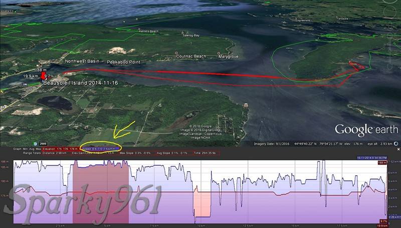
Make a track log, export it, open it in Google Earth. It’s very easy to analyze the data to give average speed. Even better, you’ll see it overlaid on a map so if you plan it right you’ll know which areas of the track log to look at. After all, your speed numbers are only worthwhile if you can keep it up over a long distance.
In the picture below, it shows how you can highlight a section in the graph and it shows the min, avg, max speed for that section. Since its a graph it’s pretty easy to tell when there’s an erroneous spike too.
Pick a known point and distance. For me the railroad bridge is one mile. Paddle out to the point (bridge) and back record time. Do the math. That’s your speed.
My cell phone service in the city is pretty good. I use a smart phone and Map My Ride app. Start a work out and it gives you distance, average and split times. Cost nothing but battery charge.
This used to read in MPH but I can’t find the setting to bring it back. I don’t have one out to the RR bridge but you get the idea of the splits and average.
@Toller said:
Well… thats the smart way to do it!
Up to now my method has been really consistant.
Or consistently inconsistent…once data exists, the next question is “what kind of error is inherent in it?”. I’m testing another set of batteries right now. My GPS has been sitting untouched on the window sill for about 4 hours. Max speed so far is 1.6mph.
For the sake of illustration, a first rough estimate of error in my gps is +/- 1.6mph. If I were to measure two runs with two kayaks and one is 4.5mph max and the other is 5.0mph max, 4.5 +/- 1.6mph is the same number as 5.0 +/- 1.6mph…which could raise the question, “Is my GPS wrong, or am I confused?”
I use an app on my phone and at points it is nuts even with a strong tide. But it does work in the car set on cruise at 60 mph for a long ride. Beyond my knowledge. Solstice GT 08 tops out at 6.3 and my Extreme at 7.0x
@fishboat1 said: Or consistently inconsistent…once data exists, the next question is “what kind of error is inherent in it?”. I’m testing another set of batteries right now. My GPS has been sitting untouched on the window sill for about 4 hours. Max speed so far is 1.6mph.
You aren’t thinking the batteries will affect the accuracy, are you? I hope not.
In every GPS you will see positional “drift” over time. The cause of which is both unnecessary and uninteresting for this discussion. Better units will have addressed this either through software or hardware. And, of course, you are limited to the inherent accuracy of the GPS satellites and current technology thereof (which, I’ll add, is pretty darn amazing)
If you were to plot the position data say, once per second, you would find that it bounces all over the place within a certain distance around your actual position. Leave it long enough and you’d find that the plot of points roughly forms a circle. This is approximately the accuracy of the unit under those conditions at that time.
What are you using as a GPS? High end dedicated unit? Budget smart phone? I’d expect these to be at either end of the spectrum in terms of positional accuracy and drift.
You aren’t thinking the batteries will affect the accuracy, are you? I hope not.
No…I don’t believe I said that. Power is power…I may be having some issues with rechargeable NiMH batteries and I was just running some tests on charging time vs run time in the gps.
As for the rest of the ‘positional’ discussion…sure…every data point is an estimate, not a true or exact location. Take an average of lots of estimates and you get a better estimate of your true position…but that isn’t what was being discussed. Though the same concept applies to the (max or avg) speed estimate.
I remember from Sea Kayaker magazine when they tested a Kayak Pro Namu–which appears to be quite similar to the Tahe 494–that had considerably better performance figures than many of the longer sea kayaks they tested. So it is possible that the 494 might well be capable of giving the Solstice a run for the money.
Two things that I find make a huge difference in the paddling experience is the tendency for the boat to track well and to not be prematurely speed limited. If the boat tends to be overly sensitive to wind, current and less than symmetric paddling force, it is very tiring to try to adjust your paddling to compensate for such factors. Likewise, if a boat that “hits the wall” and needs almost inhuman power to step it up past a relatively moderate speed is tough to deal with when you have a lot of open water ahead and the sun is going down.
I paddle the Tahe and my old Zoar Sport a half mile in light wind. They each took my 7 minutes. That is very disappointing and certainly not in agreement with the GPS maximum speeds. The Tahe is longer and narrower; i would expect it to be faster. At least a little.
The GPS is made for hiking, it is not my cell phone or a car GPS. I set it out for a half hour and it recorded a maximum speed of zero. As soon as I started walking it showed a speed of 1.5mph, which is probably about right.
The GPS is made for hiking, it is not my cell phone or a car GPS. I set it out for a half hour and it recorded a maximum speed of zero. As soon as I started walking it showed a speed of 1.5mph, which is probably about right.
What model GPS are you using? That’s a slow leisurely pace for walking. I use a Garmin Forerunner 310XT. When taking a brisk walk, my speed is 4 mph. I also use the Forerunner while paddling my kayak.

 Or consistently inconsistent…once data exists, the next question is “what kind of error is inherent in it?”. I’m testing another set of batteries right now. My GPS has been sitting untouched on the window sill for about 4 hours. Max speed so far is 1.6mph.