
Image by Dave Resler
August 10 / Day 13
Heavy fog to low overcast, Winds calm increasing to W @ 15 knots, Seas calm to swells to 1.5 meter with 2-foot chop, Seas moderate at times
I awoke on Thursday to another foggy morning. No surprise there as August is often referred to as “Fogust” when paddling the Great Bear Rain Forest. The day’s task was to set myself up for crossing Queen Charlotte Strait during the brief weather window that would open on Friday. Crossing the “Queen” to Vancouver Island is a crux move that is exposed, requires consideration and the right conditions. I had left a dozen yachts anchored at Fury Cove when I departed Wednesday morning, all waiting for tomorrow’s forecasted conditions to make their crossing. I was following suit, but being unpowered, I had to paddle for two days just to get to a place where the crossing would be possible. I was nearly two weeks without rest, had bruised ribs plus a left cheek that was tender and swollen courtesy of a surf-induced battering suffered upon my arrival at Red Sand Beach. I was pressing hard to get to a campsite where I could take advantage of Friday’s brief weather window that would allow a safe crossing of the “Queen”. That window was forecasted to open near dawn tomorrow and slam shut with a return of high winds in the afternoon then remain closed for several days. I was towards the end of my route and on the part that I’ve never been fond of. It’s the part that is littered with a disproportionate number of objective risks, timing issues, attendant critical decisions and is accentuated by the fact that the Queen don’t play. Lots of moving parts and what I really didn’t need was more fog.
When traveling south and setting up for crossing the Queen you must address a couple of significant objectives. I believe that the best strategy with winds from the north or west is to round Cape Caution shortly after the turn to flood. That takes wind against current issues out of the equation and ensures that you have time to cross Slingsby Channel well before it starts ebbing. Slingsby is one of the last places you want to put yourself in a wind and swell against ebb current situation as it is a firehose that empties the majority of the Seymour / Belize Inlet complex into Queen Charlotte Sound. Both Cape Caution and Slingsby Channel possess a great deal of potential bad juju.
I wanted to stage at Skull Cove or Shelter Bay. While Shelter Bay offers a crossing that is about 5 NM less than that from Skull it would extend this day’s cockpit time by ~2 hours. I felt that I was fading and wasn’t sure that I had an additional 2 hours in the tank. I wanted to go no farther than Skull Cove but energy not spent by stopping there would be required in the morning. I couldn’t even believe that I was so tired that I was factoring my available energy stores into the equation.
I consider the crossing from Shelter Bay to be generally less “sporting” as it reduces the length of exposure and should require less energy expenditure on Friday. One of the components that adds to a route’s “sporting” quotient is the amount of time spent in the shipping lanes. The risk posed by shipping traffic can be reduced by communicating via VHF with Comox Traffic, announcing your presence and your intent. Nothing feels quite like hearing Shipping Traffic notify a cruise ship that “Sea Kayaker White Tempest” is in play, has an established route and better not get run down. Unfortunately, my ability to contact Comox Traffic or anyone else had been eliminated by the Raven that chewed the end off of my FM antennae three mornings prior at Wolf Beach. Would that “terrifying” wildlife encounter weigh heavily into my decisions?
Choices……………

I left the beach at a little after 8:00AM with about 2.5 hours of paddling to reach Cape Caution. Visibility was poor but sea conditions were benign so I stayed in close and when I couldn’t see the shoreline, I could hear it. Passing very close to Cape Caution I angled out to the south to avoid the giant eddy that forms past the cape and well into Silvester Bay. Currents conspire to pull you into their counter rotation and it took a conscious effort and imagination to avoid it. Fog lifted to form a solid overcast down to about 75 feet which made it difficult to identify shoreline features so I was guessing exactly where I would find Wilby Point. I was ready for something to eat and I prefer Wilby over Burnett Bay as a rest stop as it is protected, a simple in and out and you are less apt to run into other travelers whose conversation will put you off your schedule.
The fog returned and I made my way across Burnett Bay by IFR. Soon enough I approached Slingsby Channel under ideal current conditions. Ideal conditions at Slingsby doesn’t mean flat water. Even with low wind and a flood current the surface gets odd as waves and swell bend and collide creating a texture that can be fun if you can see it but not-so-much fun if you can’t. I spent 20 blind minutes of weirdness crossing the mouth of the channel.
Nearing the southernmost end of Braham Island, I reassessed my options of camping at Skull Cove or Shelter Bay.
• Skull Cove was less than 2 NM away. I could get to Skull close high slack of 4.1 meter but would be leaving in the morning at 2.5 meter. Never having seen the place at low tide I didn’t know if it would allow me the luxury of leaving when I needed to.
• Shelter Bay was over 7 NM away and would require a 2.8NM zero-visibility crossing. I didn’t really think that I had another 2 hours of paddling left in me and I wanted to be done with paddling by Braille……at least for the day. If I went to Skull Cove and it wasn’t viable I would have a 2NM blind crossing to make while paddling an additional 6.5NM to make it to Shelter Bay.
I was beat, hoped for the best and reluctantly chose Skull Cove. It is not on my “A-List” for many reasons and at this time was a bad choice as even at 4.1 meters it is very boney and at 2.5 would be pretty awful. I toured Skull Cove looking for a better, steeper beach but finding nothing I tried to get my mind right, ignore the pain, took three Ibuprofens and started for Shelter Bay.
I chose a course of 120 degrees that I felt would get me safely through the fog and north of Southgate Island. From there I would simply follow the coastline that would lead me to the narrow channel between the Southgate Group and the mainland and continue down the coast to Shelter Bay. Foolproof, right?
It was an active crossing as the wind picked up and the conditions got somewhat snotty. When the tall rocky shoreline finally emerged from the foggy gloom I was pleased and assumed that it was leading me to shelter behind the Southgate Group. What I came to realize was that I had almost missed Southgate Island altogether and was on the westernmost or outside end of it. I hadn’t anticipated the effect of the southward flowing current pushing me so far off course.
The texture of the water was making more sense to me now as it was colliding with the current in Queen Charlotte Strait and both were bucking the 15 kt wind. If I had been able to see anything on my way across it would have been easy to interpret and accommodate but instead here I was on the wrong side of my intended cover. The ragged water became more so as the swell reflected off of the steep shoreline and progress slowed significantly. Enjoyable water under other circumstances but I was tired and visibility very extremely limited. A white pleasure cruiser appeared out of the fog headed north and we passed in opposite directions about 40 meters apart. He was pitching and rolling all over the place and having a very rough ride of it. I felt fortunate to be in the craft better suited to the conditions.
Rounding the point of the island the passage between Southgate Island and its neighbor, Stevens Island, angled back towards cover. Here, the combined wave height was the same but standing waves struggling against the stiff current replaced the energy-sapping clapotis and offered a welcome sense of organization that allowed me to relax and focus my available energy resources. It took time and patience to surf my way upstream to cover but at least I wasn’t getting beat up any more.
I landed at Shelter Bay at 6:40PM. Since 8:00 AM I had been out of the boat for only 15 minutes to eat lunch at noon and another 5 minutes to pee at Skull Cove. I had been paddling over 10 hours and started out the day seriously beat and not in the mood for drama or physical exertion. I was too tired to unload and set up camp so I clipped myself to the boat, laid down on the beach, closed my eyes and went to sleep.
I awoke at some point and went about the evening chores of unpacking, setting up my tent, sleeping bag and pad, carrying my boat to the edge of the forest, securing it to a tree and eating my usual pre-Queen-Crossing meal of Mountain House Freeze-Dried Breakfast Skillet.
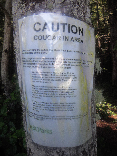
Time for bed but there was one semi-nagging thought. There was this sign warning about Cougars in the area. It said “Caution Cougar in Area… Arm yourself with rocks, sticks or weapons…. Maintain eye contact with the cat. Show your teeth and make loud noises…. If the Cougar attacks fight back. Keep the animal in front of you at all times. Convince the cougar that you are a threat, not prey. Use anything you can as a weapon. Focus your attack on the cougar’s face and eyes".
I was thinking that if a cougar was stalking me after landing he/she would have eaten my sorry butt while I was sound asleep on the beach and tethered to an immovable object. Missing that opportunity, it was dealing with a pXssed, bitter and tired man who had no time for their crap and was best not-messed-with.
I took three Ibuprofen, thought about showing my teeth and was asleep before I could count to 10.
27.4 NM.