Well, I’d add this as Trip in Go Paddle…but it might extend beyond what one would consider a reasonable trip. And it doesn’t support photos, so here it goes:
In the summer of 2024, my partner and I embarked on a “sea-to-source-to-sea” trip. We hiked from the Pacific Ocean to the source of the Columbia River. We then picked up our sea kayaks and paddled all 1200 miles back to the ocean.


I’ve gleaned so much helpful information from this community in preparation for this trip. In writing this trip report, I can only hope to give back a fraction of that knowledge. When googling “Columbia River source to sea paddle”, you’d be hard pressed to find much more than a book and one or two trip reports. If you have any questions at all about this journey, don’t hesitate to ask.
The River
To describe a complicated river simply: the Columbia is long, steep, and dammed. It is the 4th largest river by flow in North America. Where the Mississippi (1st) and Ohio (3rd) rivers drop <0.8 ft/mi on average, the Columbia drops >2 ft/mi. This wasn’t unnoticed by the US government and the Bureau of Reclamation, however. There are 14 dams in US and Canada along the main stem of the Columbia. One of them, Grand Coulee, is so large that the amount of concrete used could fill Texas one-inch deep.

It’s not all about hydropower, however. The Columbia is also home to some of the largest intact wetlands in North America. It’s geology boasts constant signs of historic floods of both lava and ice age water. Some of the earliest signs of human activity on the river were dated back to 11,230 years ago. The fascination of a Northwest Passage made the river a cultural focal point of European & American explorers.
In our own way, we kind of broke up the river into in these 9 sections:
-
(mi 0-147) The Wetlands: Some of the longest intact wetlands in North America. Countless bald eagles, herons, and ospreys. Soul-sucking mud, limited camping options, and glacial silt made this stretch a bit tedious. The towns of Invermere and Golden definitely make up for it.


-
(mi 148-298) Big Bend Country: The Columbia shoots north here, making it all the way to 52 degrees of latitude. This section was by far the most remote. Even the sound of a motorboat here was rare. Timber trucks and clear cuts still managed to litter the shores. Big reservoirs like Kinbasket Lake (~77 miles) and Revelstoke Lake (~80 miles) serve as a pretty good entry into flatwater paddling.


-
(mi 299-520) West Kootenays: This section revolves largely around Arrow Lakes, our 2nd longest lake of the trip (~135 miles). Without competition, this also proved to be our favorite section of the entire paddle. The transition from towering cedars to vibrant ponderosa pines does not go unnoticed. Early September also provided several streams with strong Kokanee spawns. Towns like Revelstoke, Nakusp, and Northport all provide fantastic access off the river.


-
(mi 521-690) Okanagan Highlands: Think hills dotted with sage and scoured scablands of basalt pillars. The transition occurs somewhere near the confluence of the Kettle River in Lake Roosevelt, the longest lake on our journey (~140 miles). In this section, we started a series of more frequent dams and portages. We frequently saw Bighorn Sheep as well as the occasional black bear.


-
(mi 691-830) Central Washington: We really don’t have a great name for this section, but if the previous section of river stored water then this section generates the power. We nearly encountered a dam every day on this stretch. Some flow in the river is perceptible, but it’s slackwater for the most part. Here is really when we started to feel like we were back in civilization.


-
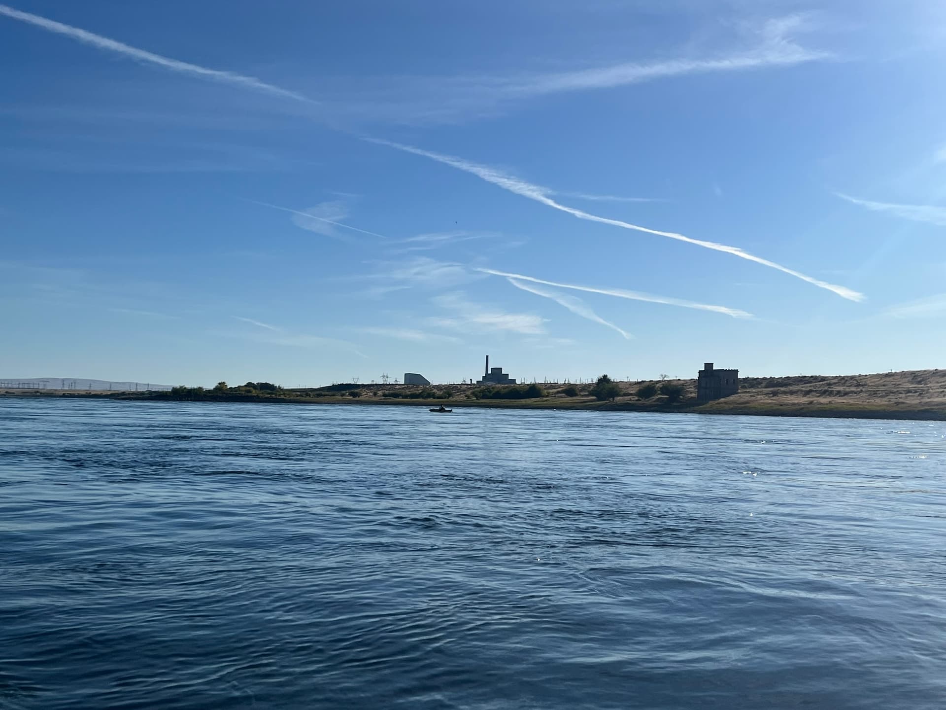
(mi 831-889) Hanford Reach: A short section, but so unique when juxtaposed to the sections before & after that it deserves it’s own section. The Reach is a free flowing section - and a fast one at that. We generally got 3-5mph extra of flow. The landscape is stark and barren. Completely flat too. The river is the only thread of life that dots the landscape. Well, that and the Hanford Nuclear Reservation. Both sides of the river are technically restricted which makes getting out of the kayak “illegal”. Many paddlers tend to do the whole ~35 mile camping exclusion in one stretch.


-
(mi 890-971) Snake Confluence: After the confluence, the shipping traffic makes the Columbia less of a river and more of a billion dollar-a-year export business. We started seeing barges and large cruise ships in this section. The wind also really started as well. We’d of course had wind in the last 890 miles, but nothing like this. Areas like Wallula Gap seem to have a near constant headwind. If the West Kootenays were so clearly our favorite, then this was the least favorite.


-
(mi 972-1108) Columbia River Gorge: The level of difficulty and scenery on the Columbia suddenly both skyrocket together. The Gorge delivers us from dry grasslands & desert to lush rainforest in less than 80 miles. Winds rocketed against us while reaching as high as 30+ knot gusts on some days. Planning around the wind forecast made for some interesting days.


-
(mi 1108-1210) Tidal Columbia: While tides affect the river as far up as the last dam (Bonneville, 1068 miles), it really affects the Columbia in the last 100 miles. The river at Kalama, WA can actually flow backwards up to two times per day. Mastering the tides and dodging the newly introduced ocean vessels proved to be another challenge. Curious harbor seals and long sandy beaches made it worthwhile.


There’s all too much to say about the river in such a short space. Let’s move onto what boats we decided to use.
The Kayaks
We largely stuck to what we knew: Delta’s performance touring line. I had a 17’ while my partner had a 15.5’. Our setup wasn’t much different from what we used touring the Puget Sound, funnily enough. The conditions on the Columbia ended up being pretty similar. Some days we’d have glass. Some days we’d experience wind swells up to ~3 feet.

As noted above, the Columbia is severely dammed. Out of 1200 miles, there are maybe only ~220 miles with notable current (in late summer). But, if the river existed as it was pre-1930s, we wouldn’t be taking sea kayaks down it. Several waterfalls and rapids were submerged by reservoirs behind dams.
Finally, we were happy we had light, thermoformed kayaks. We were doing self-supported portages for the trip. This meant hauling our kayaks onto each of their own carts and wheeling them around each dam.
The Portages
Now that I’ve mentioned it, I should probably address it first: there were 14 dams on the entire trip which required 13 portages (Hugh Keenleyside Dam near Castlegar had the only navigational locks we could go through). Then there was 1 additional portage for the US/Canada border (which doesn’t process watercraft). These ranged from immensely difficult to borderline trivial.
These portages were certainly the logistical crux of the entire journey. Different agencies manage a lot of different dams. And each agency seems to have their own attitude towards paddlers. Some would provide a map or even a security escort. Some would effectively tell us to “get lost”.


The first few dams took some time but we eventually got the hang of it. There were even some days in Central WA where we’d be portaging two dams in one day.
Portage routes ranged anywhere from 0.75 miles to 4 miles.
The Rapids
If you’d like a quick laugh, check out the Wikipedia page on rapids on the Columbia River. CTRL + F and look for “submerged”. Almost every rapid on the Columbia now hides beneath some reservoir.
There are now only 5 areas along it’s 1200 course where rapids remain:
-
(mi 14) Fairmont Hot Springs: So minor that the biggest challenge here is dodging drunk people floating them in tubes.
-
(mi 138) Redgrave Canyon: Probably the most difficult rapids on the entire river. They are the last bit of excitement in the first 100ish miles before entering Kinbasket Lake. Probably Class 2 depending on flow & season. Spilling here would be…undesirable. The steep canyon walls would make getting to shore difficult. I’d recommend watching this on Instagram (courtesy of the only two other thru-paddlers we met on the river).
-
(mi 450) Tincup & Rock Island: These rapids near Castlegar, BC are definitely worth preparing for. Whirlpools and water moving under the surface was more a threat than the rapid itself. Likely both Class 2, but just due to whirlpools and rocks that can flip you in low water.
-
(mi 486) Deadman’s Eddy, Steamboat Rock, and Little Dalles: This is another set just downriver from Trail, past the US border. Same as above - nothing terrifying in the rapids themselves, but there is a large amount of water doing weird things below your boat. The Eddy is so pronounced that apparently, all lost boats from Castlegar/Trail end up here.
-
(mi 840) Coyote Rapids: Hardly noticeable, but these serve as the last set of rapids in the entire river.

The Gear
A lot of the camping gear used was the same gear we’d used for ultralight backpacking. We ended up camping in dispersed or established sites >90% of all nights. The thought of putting a full gear list here makes my head hurt, so I’ll list our favorite pieces of gear instead:
-
Kneeling pad - This was a surprise for us, but both of us agreed this was our favorite piece of gear. Doubled as a sit pad during camp or lunch as well as a heel pad while sitting in the kayak.
-
Paddle leash - The mind loses the ability to not drop your paddle after 30ish days of continuous paddling. Happy to not have to track our paddles at all times.
-
Camelbak or bladder reservoir - I used this extensively. Not only to drink while I had my skirt on, but it worked really well for flushing lines like the rudder or seat control line! The beginning of the river has a crazy amount of sediment that would’ve wreaked (more) havoc on the lines.
-
Katadyn BeFree’s - Great water filters. We both used our own filters for almost the entire river, stopping when it got brackish at around mi 1180.
-
RAILBLAZA C-Tug carts - These were exactly what we were looking for when it came to kayak carts. They were the absolute lightest we could find (10 lbs) and they survived all 14 portages (just barely).
-
Zpacks Duplex, Thermarest Xtherm’s, Enlighted Equipment 20 Revelation Quilts - Sleep was incredibly important on this journey. We averaged over 8 hours per night. I’m not sure we’d ever consider subbing out our tent, sleeping pads, and quilts.

The Numbers
The entire paddle took us 48 days from August 19th 2024 to October 6th 2024. That lands us with a nice, even average of 25 miles per day. Here are some more random stats:
-
Longest day - 49 miles (in the free flowing Hanford Reach)
-
Shortest day - 0.6 miles (in the Columbia River Gorge…with 20kt headwinds)
-
Zero days - 3 (no miles paddled)
-
Nights spent dispersed/primitive camping - 26 nights
-
Nights spent camping in established sites - 18 nights
-
Nights spend indoors - 4 nights
-
Average daily caloric burn - 3,865
-
Number of other paddlers seen - 12
And that’s all for now. Again, would be happy to answer any questions. I also have a Caltopo map with mile markers and points-of-interest that I’d be happy to share.
Would also be curious to hear if anyone else has thru-paddled the Columbia? Or large sections of it? It might not be as unheard of as we thought.
