I am planning a long canoe expedition/vacation and am having issues finding the right maps needed to link waterways. Starting in June, I will be doing the Allegheny to the Ohio to the Mississippi, head north and into Canada where I would like to make my way across Canada via different connecting rivers/lakes and into the Yukon where I will finish in the Bering sea. Anyone know of a good map source or have ideas on rivers for connections?
Thanks in advance.
are you sure?
I’m not aware of any navigable river systems that interconnect between the source of the Mississippi and that of the Yukon. They are in different continental drainages and there are mountain ranges and vast regions of trackless muskeg and boreal forest between them.
Have you read narratives by people who’ve canoed the rivers you are considering?
Big reality check called for
www.mikeranta.ca
He paddled across Canada and is just now pulling into Cape Breton having started in Vancouver BC
It took
2 years. He paddled 12 hours a day every day or more
The Yukon travels north from Lake Bennett. It can be reached from Skagway AK via the Chilkoot Trail a 33 mile 4000 foot mountain climb
It’s over 1000 miles ocean paddling from Vancouver to Skagway
It takes 40 days to paddle the Yukon to the Bering sea
I’d get out of the mushroom patch
June is too late and maps are the least of your issues
Topo Canada maps are online
You at the very least ought to attend the Wilderness Canoeing Symposium in Toronto for more realistic two to three month trips.
Leaving aside…
that if you don’t already know which rivers you’ll need to paddle up through Canada for your big adventure and you don’t seem to have enough paddling experience on unfamiliar rivers to know at least some sources for maps, you’re probably not qualified at this point to make this trip…
Here’s what I’d do.
- Look at a good atlas of Canada that shows all the major rivers. You can find that online or in probably any library or bookstore. Pick out possible routes.
- Google Earth. You can measure mileages of the rivers very easily with the ruler tool, and thus know how far you’ll need to paddle from starting point to ending point, plus how far you’ll have to portage between river systems, and what kind of terrain you’ll have to cross.
- Use a search engine to look up every river. Some may not have much info, but any river that is paddled regularly will have at least some paddling info on the internet. If you can’t find any good info, that might mean it’s not “paddle-able”, and it at least means you’re going to have to dig deeper for info. You should also be able to find fact sheets and books on some of the rivers. Order them.
- The U.S.G.S website will take you to online topo maps of every stream valley in the country, and ditto with the Canadian site mentioned above. Your Google Earth investigation should have given you some idea of the terrain; the topo maps will give you a much better knowledge of river gradients and the true steepness and relief of the terrain. You should probably order the real paper topo maps, or at least the detailed downloads, for every part of your route.
- Then I’d go back to Google Earth, and do screen captures of every stretch of stream where you will have to be camping (there will be a lot of them up in Canada), and every stream that may have rapids. Make the screen captures of close-ups that show only a few miles of stream on each, print them, and study them closely for campsites, portage possibilities, and dangerous rapids, along with anything else useful such as cabins or other landmarks. Mark every landmark for GPS coordinates.
- After that, you’re on your own!
Thank you
I have been reading a lot about the different rivers and reports from what others have paddled. I am pretty set on making this trip and have nothing but time to do it in.
Thanks again for your response.
I am familiar with Peter Marshalls
trip of 2600 miles across Canada from the Pacific to Hudsons Bay. West to East
I suggest you watch it. Its free
http://vimeo.com/62972063
Google Maps is not very useful in northern Lats. It is fun to trace and try to get an idea of the route but the resolution in unpopulated areas is not good.
Jay Morrison crossed all of Canada some 10 years ago. He is a strong paddler. It took two years.
Two friends of mine paddled from Oregon to South Carolina. It took two years
Paddling up the Mississippi? Hokay…Its not a lazy river…
Marsh Lake to Dawson city
This one covers the start of the Yukon river.
http://www.yukonbooks.com/shop/customer/product.php?productid=2818
Yes. Miss to Yukon
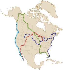
Landick and Kruger connnected Miss to Yukon during their 28,000 miles 2 1/2 year paddle. Go up the Miss into the Fur Trade route across Canada into the Athabasca, Slave, Mackenzie drainage then up the Bell, Rat River portage into Pocupine into the Yukon River.
Here is link to the entire 28,000 mile route etc. http://4.bp.blogspot.com/-F7xNuTPfo_o/UbcoWDSU00I/AAAAAAAAInU/gBrfVLG6Z6Y/s1600/North_America.gif
Read Krugers book of detailed route
– Last Updated: Oct-15-16 12:20 PM EST –
Brand Frenz and Kruger co-authored book. "The Ultimate Canoe CHallenge" about Krugers and Landick's 28,000 miles 2.5 year paddle trip.
The book details ever river, lake and stream so you could use that to link up their route.
I actually have all the maps you need, but I bought them via Maps Canada back before the digital age. You should get this book to see the route.
AND OR google Fur Trade Route of Canada....its easy to then see where you need to link the Mississippi to the Fur Trade route.
Your crux is the Bell/Rat River portage from Mackenzie river side over MCdougal pass in the Porcupine river. Its been done a lot actually.
I can get you some emails of folks besides Kruger who has done that.
You may just want to print off the maps you need online that what most folks do now.
Anyway---Here is the book with the detailed route description. http://www.amazon.com/Ultimate-Canoe-Challenge-Through-America/dp/0595335799
Wrong data there.
Ranta completed his route NOT in two years. He departed from the Pacific I believe in April…so about 6 months it took him. This is his second crossing of the continent. He did it two years ago as well in the same amount of time…6-7 months.
Clint Waddel and Verlen Kruger went from Montreal to the Bering Sea in 1973 in 6-months, 8000 miles along the historic Fur trade route then to the famed Rat/Bell River portage etc.
This guy here that is requesting help and answers wants to link up the more challenging part that is from the Mississippi into the fur trade route. The book “Ulitimate Canoe Challenge” is a detailed account of Landick and Krugers 2.5 year, 28,000 miles paddle trip. They too came UP the Mississippi and into the Fur trade route.
Basically when you reach the source of the Mississippi at Lake Itasca you need to work your way towards Ft. Mcmurray Alberta, a distance of 2,100 miles which took Kruger and Landick (both in solo canoes), 49 days to complete this section.
You will need to get into WILD RICE River from Itasca which is a tiny stream that flows into the Red River. (Sucker Creek takes you to the Wild Rice fyi) Sucker Lake, to Long Lake, portage across Mn Highway 200 to Mud Lake and Heir Creek., and that flows to Wild Rice River. and then its 140 miles to the Red River. They had LOW water and hike up to town of Zerkel to the bridge which had water for them. Red River runs into Lake Winnepeg. From there…well duh!–The Canadian Fur Trade Route which would include the huge Methye Portage . I believe they went from the Churchill River to Reindeer Lake etc…that route. Again, purchase the book for mile by mile account.
You may want to contact the Rediscovery North America Expedition who this summer won Canoe & Kayak Magazines “Expedition of the Year” for their 9 month paddle from the Gulf of Mexico to the Arctic Ocean. Google the expedition and you can get ahold of them via their Facebook and other accounts. Not sure exactly where they connected with the fur trade route but they cut off that route to work their way to the Arctic instead of the Yukon is which you want to go down.
Google Bell?Rat River portage over McDougal Pass into the Porcupine too. I know a few who have paddled across canada too and went that route, I will get you their email contacts when you send me a message.
You may also want to read Joanie and Gary Mcguffins book about paddling across Canada in the 1980s. They went from Montreal to Tuktoyaktuk. I cannot remember the name of the book, but just google the authors, they have written many books.
If you do the Facebook Thing, there are several groups that have a HUGE amount of info and thats the Mississippi River Paddles page and the Mackenzie River Paddlers page. Lots of folks on their have done those rivers and can provide a lot of info.
Up Mississippi
– Last Updated: Oct-15-16 12:55 PM EST –
Here is Rediscovery North America Expedition route.
You can see on the map where you would need to veer from that Yukon route...that being Great Slave Lake. http://www.rediscoverna.com/the-route/
FYi, their recent documentary just came out two weeks ago and you can purchase and see the trailer at the link above etc.
I think they took about four months to paddle UP the Mississippi from the Gulf. Kruger and Landick completed all 2400 miles upstream in 84-days and Kruger was 62 years old. You'd be joining at the Ohio so you would shave off 1000 miles of upstream paddling.
maps
– Last Updated: Oct-15-16 5:05 PM EST –
I paddled the yukon river quest race from Whitehorse to Dawson in 2008 and 2013, and the Yukon 1000 mile race from Whitehorse to the Dalton Highway in 2009 and 2011. The outdated Canadian topo and USGS maps are all but worthless, as the river changes so much, practically every year. We paddled in sections of river that were shown as solid ground on the maps, and there were places were the land was actively being carved out, falling into the river as we paddled by. I found Google Earth to be recent and excellent and well registered with my GPS and with reality on each race. I pre-plotted my route on GE, and printed more than 90 GE pages for the 1000 miler route, and waterproofed each one before placing them in a binder to take with me. On each passage the river was different in many places than on the previous trip.
Maps are useless?
– Last Updated: Oct-15-16 10:08 PM EST –
I guess I can't see maps being "useless". I can (perhaps) see how if planning a route for racing, in cases where a river is highly braided, that you'd want to plan, to the extent that is practical, which particular subchannels to take, because racing is a situation where minutes count and taking a side channel that's even slightly more indirect than another could cost you time. But for just getting "from here to there" while going downstream, how does an incorrect map matter at all? If you find that the location of a nice, high-and-dry campsite plots on the map as being in the middle of a river channel, or that your actual paddling route sometimes takes you across places where the map shows no channel at all, well, that's interesting, but of no consequence. The river will still end up at the same location, and you'll get there too if you stay in your boat.
As a very small-scale example of this, there was a time when paddling down one fairly large river, our group intended to paddle a mile or so upstream on a major tributary to buy ice cream at the first town. One fellow located the mouth of that tributary on his GPS, and when we got there and all that was present was a shallow inlet of stagnant water leading far back into the woods, he insisted that this was the tributary we were looking for because his GPS told him so, while any mildly-sensible person could simply tell by the fact that there was no current that it was a dead-end. Pointing out the obvious to him was no good because his GPS "couldn't be wrong." Well, it turned out that the real mouth of the river was less than 50 yards downstream, and there was a tremendous rush of muddy water pouring out of it. The slackwater inlet had in fact been the mouth of the tributary sometime within the last 50 years, and was still shown that way on the map being used by his GPS. The point is, the fact that mouth of the tributary had moved and the map was therefore "wrong" shouldn't have kept anyone from finding it.
Oh, and here's a hilarious example of this: I was just watching a portion of the movie "How the West Was Won" on TV, and the part I saw was where a family of pioneers crashed their raft in terrible rapids because they "took the wrong fork" of the river (supposedly, the fork that they were supposed to follow was all flatwater). Wow. Talk about using artistic license to suspend the laws of physics and the way those laws affect river geology. I would hope that most people watching the movie would have instantly realized how impossible that situation would be! Again, the point is, if you are on the river and going downstream, you can't find a way to get lost (though two of the hillbillies in "Deliverance" sarcastically stated otherwise ("You see, this here river don't go anywhere near Aintry")).
Update: I just "flew" the river's course from Whitehorse to Dawson via satellite photos, and it's obvious that the river's course is well established nearly everywhere and not changing rapidly (there are good clues to this in the topography and vegetation). I did see one large braided section (where the bed load below a major tributary exceeds the Yukon's carrying capacity) which would obviously have channels that change drastically from year to year, but all within the confines of the main riverbed. So again I wonder, who would care if the maps can't keep up with such things?
Update #2: I just "flew" from Dawson to the mouth, and there are some larger braided sections, and a really long flatland section with amazing textural traces on the bottomland showing how the various channels "creep" over time, indicating that for the major channels, changes in course are happening in the normal way. Pretty cool stuff (!) but no reason fret about finding the way.
map
http://geology.com/lakes-rivers-water/oklahoma.shtml
I view river sections in Google Earth
transfer coordinates into Garmin 78 with Topo USA
mapping rapids n takeouts
by name, rapids n takeouts are searchable in Google Images
and Utube
for each river there may be an associated canoeor kayak club nearby…also searchable for example Iowa Canoe Clubs
and Blogs
search: Iowa canoe Blogs
the Upper Mississippi or the wilder sections of the Missouri are starters
buy a global location beacon…a PLB
useless maps
– Last Updated: Oct-18-16 10:11 AM EST –
If you are looking at Canadian or USGS topo maps of the Yukon River, and compare them to Google Earth, there are many places where, at least for planning purposes, there are significant differences when compared to reality of being there. that's what i mean by those maps being useless. Gravel shoals come and go annually, but it is true that if you just stay in the current (any current), it all drains downhill. Great for tourist paddling, not so much for racing. GE images are generally only a couple of years old, while the topo maps are decades old.
The best current is often determined by sharp deep bank cut terrain and where subsurface gravel and silt deposits alter the flow rate. it is true that between Whitehorse and Dawson, the change over time is nothing like the changes in the "Flats" of Alaska below Circle, but there are changes nevertheless before Dawson. Enough to make a notable difference in current and paddling speed. Have you tried to pick your way around the curve at the mouth of the Stewart River, as the islands erode and shoals are deposited? You could almost walk across the river there in most places while searching for a deeper channel. Anywhere below where the White River enters the Yukon, you can expect to run into silty gravel shoals that were most likely not there last year.
I'll spend my winter using GE to "fly" down the Yukon, as I work out on a paddling machine at the same time, refining my GPS route based on what i remember at specific locations from my last trip. I actually memorize the turns and the short cuts, enough to recognize them upon real-time arrival and what to expect as i approach, enough to steer into the fastest channel current and evaluate current and shortest distance against shortest travel time.
In 2009, in the Flats on the 1000 mile,we were about to be passed by another canoe from behind, when we must have been over confident enough and relaxed too much during the past few hours to let them creep up on us. We happened to be at a place where the main channel made a wide looping sweep and there was a preplanned possible shortcut available at that location. When I saw him make the turn to the main channel, I told my guys: "we're taking the shortcut" which saved us a distance of almost 2 miles over taking the main channel. Long story short, 2 days later we finished well ahead of our competition, never having seen him again on the water. Even so, there were unexpected shoals in our shortcut channel that slowed us more than i wanted because the initial rapid flowing current into the short cut widened and slowed more than I hoped. So in 2011 I avoided that particular short cut channel and found another with current that remained fast until rejoining the main river channnel a couple of miles downstream.
In the area around Circle, even before the Flats, the existing landscape is not at all what the topo map shows. in 2011, the shoreline was actively falling into the river. My GPS map showed us paddling on solid land. We camped on a muddy extension of an island not shown on the map.. Well below the Flats, channels open and close, sometimes allowing you to follow the fast current into a cut through a shoal to get behind a long island. The big bend just below the Kandik River is almost as bad as the Stewart. Further down, you really need to know how to read the surface current and understand what helicoidal currents can do to your course. In the cutoff slough that I call the "W", (from its shape in GE), you can cut off a 3 mile loop of the river, but the entrance to the W is nearly blocked by a changing gravel shoal and island, making it difficult to enter if not already padddling in the channel current flowing in. If I were only looking at the topo map, I would likely not consider taking the W at that particular slough.
The YRQ race had long been advertised as 460 miles from Whitehorse to Dawson. But that was likely following the main channel that the old paddle wheelers traveled. My measurements on GE, taking reasonable canoeable shortcuts out of the main channel, came out to 426 miles. The Actual tracks on two separate GPS units recorded almost exactly 426 miles on 4 separate trips down the river. my mapped waypoints are named with their distance from Whitehorse, calculated and labeled by distance to within a tenth of a mile. All along the route the accumulated GPS distance agreed with arrival at each waypoint to within a few tenths. I've done the same calculations with GE on other river and lake routes. The GEregistration with reality is usually excellent.
That agrees with my thoughts
It’s advantageous to a racer to plan his route as accurately as possible.
To someone like the OP, he’ll get to his destination whether or not the latest changes (or those of the last 50 years) are accurately mapped or not.
2 cents
Might be worthwhile for the OP to do the Yukon… not worry about the actual course as he is not racing…
It all goes downstream. Mistakes will be made. He has enough time to make them.
Some guidebooks for the Yukon
http://www.yukonbooks.com/shop/customer/home.php?cat=48&page=2
Thanks
Thanks to all for the ideas and links to maps and offers of assistance. i will take you up on them all. Some are right, I am in no hurry, just won’t be thrilled to get caught in the middle of the winter in the middle of nowhere but have a feeling I will be just fine.
mytopo.com
You can get custom maps printed with your choice of scale and size at mytopo.com. You can get them in waterproof as well.
Alan