There was an older discussion that someone was asking how to convert Cubic Feet Per Second to MPH. I was going to add this question to the bottom of that one, but now I can’t find it again!
My question is: Does anyone know of a GPS app or device, that will record speed, and display that speed on the map? It is easy to find app’s or devices that will record a track, and give you times, which it uses to compute average speeds. I’m looking for something much more precise. I would like the device to record the speed, and note any 1 mph change in speed. Whether it records speed and marks it every 30 seconds (or 5 seconds to 30 seconds) OR if it notes and records the CHANGE in speed… either way is fine.
The way I would like to use something like this is… I want to float the device down the river (my stretch of river is 32 miles). If I float it down the river, at 3 or 4 different times, at different published CFS discharge rates… I should be able to make a spreadsheet that will tell me in mph, what the water speed is at any point of the river, just by entering in the published USGS discharge rate.
I’m sure some will roll their eyes at my request… But it will tell me if I can make the 32 miles up-stream, in the time I have to do it.
Thanks in advance for any recommendations on how I might accomplish this!
I’m not aware of any device that will provide the exact information you’re looking for.
When I’ve used a SPOT device, it will place a point along your track on its map at whatever time interval you select in its settings. It MAY be possible to click on each of the points and see speed and time (I’m not sure on all the SPOT features, my SPOT subscription expired long ago). With a bit of data gathering and interpolation your part, you could probably extract the information you are looking for.
The drawback is the SPOT would require a costly subscription and the SPOT can be annoyingly finicky to use.
There may be some free apps that would create a similar “breadcrumb track” at a set time interval, but I’m not aware of them.
This sounds like an interesting exercise, keep us posted.
My Garmin Forerunner 310XT is set up to record my speed, distance, time (and HR if I wear a monitor). Once the data is transferred to Garmin Connect it displays it on a map. While it averages the speed, it also graphs it so I can play back my trip on the map and see the speed traveled quite precisely (records in tenths of a mile) throughout the journey. No subscription fees and waterproof.
Maybe more money than you want to spend if you’re looking for a one-time use gizmo. I’ve found it very handy since it can be used on land or water.
I use a wrist mounted Garmin GPS device (and their Connect app) and I like the results it produces.
The problem I have with your question is that Cubic Feet per Second is a measure of flow and not speed and their relationship is not simple. The speed of the water would depend on how restricted the flow was and other stuff like bottom friction. Think of it this way, if I turn my garden hose on full and say I’m getting a flow of 5 gallons per minute, how fast is the stream of water coming out of the nozzle at the other end? Well that depends on whether I’ve got full, shower, jet, etc. selected on the nozzle.
I think you’d have to go measure it in various places to get an empirical result.
Kayaking in the Dark Ages before Aps and online flow reports. Take your kayak down to the river and try paddling upstream. You should know within an hour if you have enough speed to make 32 miles in your desired time. Or you could find an average looking stretch of river and throw a log in at a measured point and record the time it takes to cover the distance. All of it is going to be easier than converting flows to floating velocity and integrating over 32 miles.
The real problem with doing this is when we paddle upstream we paddle in eddies at the side of the river or below obstacles that impede the flow - so your measured total flow will not match the velocity of water you are actually paddling against.
@Rookie said:
My Garmin Forerunner 310XT is set up to record my speed, distance, time (and HR if I wear a monitor). Once the data is transferred to Garmin Connect it displays it on a map. While it averages the speed, it also graphs it so I can play back my trip on the map and see the speed traveled quite precisely (records in tenths of a mile) throughout the journey. No subscription fees and waterproof.
Maybe more money than you want to spend if you’re looking for a one-time use gizmo. I’ve found it very handy since it can be used on land or water.
From a quick google search, the Garmin Forerunner 310XT is a small device that you wear on your wrist, correct? That sounds like it would work pretty good! Would you happen to know if Garmin makes a larger gps that can be mounted to the kayak, that you can transfer the same information? I’ve thought about one for a back-up for navigation when I’m too far away from shore, and the weather gets bad.
@Fourrunner said:
I’m not aware of any device that will provide the exact information you’re looking for.
When I’ve used a SPOT device, it will place a point along your track on its map at whatever time interval you select in its settings. It MAY be possible to click on each of the points and see speed and time (I’m not sure on all the SPOT features, my SPOT subscription expired long ago). With a bit of data gathering and interpolation your part, you could probably extract the information you are looking for.
The drawback is the SPOT would require a costly subscription and the SPOT can be annoyingly finicky to use.
There may be some free apps that would create a similar “breadcrumb track” at a set time interval, but I’m not aware of them.
This sounds like an interesting exercise, keep us posted.
Interesting… I hadn’t thought about SPOT at all! I had a couple of them in some trucks in the past. I just used them to be able to locate the trucks, and re-route if things came up. I never thought to look deeper at the information, or at what other information it might have provided. I’ll have to see if I still have one around!
@kfbrady said:
I use a wrist mounted Garmin GPS device (and their Connect app) and I like the results it produces.
The problem I have with your question is that Cubic Feet per Second is a measure of flow and not speed and their relationship is not simple. The speed of the water would depend on how restricted the flow was and other stuff like bottom friction. Think of it this way, if I turn my garden hose on full and say I’m getting a flow of 5 gallons per minute, how fast is the stream of water coming out of the nozzle at the other end? Well that depends on whether I’ve got full, shower, jet, etc. selected on the nozzle.
I think you’d have to go measure it in various places to get an empirical result.
Perhaps you miss-read, or I didn’t explain as fully as I could have. You mention needing to “measure in various places to get an empirical result”. That is exactly what I’m attempting to do. With a speed, in mph, measured every 5 to 30 seconds, you have exactly that. If you repeat the test at the minimum of 3 times, at different Cubic Feet per Second flow rates, you can fairly easily make a curve that should be pretty close to reality.
Is your wrist mounted Garmin GPS device the same one that @Rookie mentioned? Garmin Forerunner 310XT?
All you need is the data from your gps. (via Garmins Basecamp (free) or some other app)
The ‘difficult’ part will be floating your ‘device’ (gps) down the river.
The ‘easy’ part it tracking the ‘speed’.
Any gps will track location & times which then translate to speed.
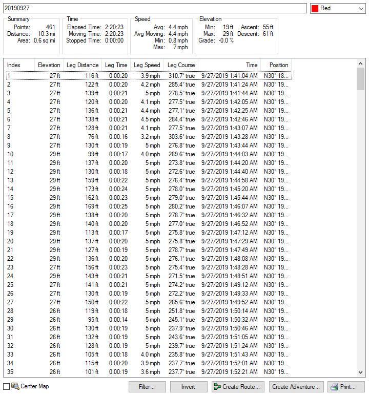
For example, here is a snapshot of part of my paddle this morning:
Here is a snapshot of the trip with ‘relative’ speeds shown (using GPSVisualizer):
(note the ‘slow’ speed going against the (tide) current, and the increased speed with the current.)
@raisins Wow! Thank you very much for posting that! That is exactly what I’m looking for! What GPS do you use? My only experience with GPS is with either google maps on my android… or the Garmin in my car, or the Garmin Dezl in my semi’s.
@Rookie said:
My Garmin Forerunner 310XT is set up to record my speed, distance, time (and HR if I wear a monitor). Once the data is transferred to Garmin Connect it displays it on a map. While it averages the speed, it also graphs it so I can play back my trip on the map and see the speed traveled quite precisely (records in tenths of a mile) throughout the journey. No subscription fees and waterproof.
Maybe more money than you want to spend if you’re looking for a one-time use gizmo. I’ve found it very handy since it can be used on land or water.
From a quick google search, the Garmin Forerunner 310XT is a small device that you wear on your wrist, correct? That sounds like it would work pretty good! Would you happen to know if Garmin makes a larger gps that can be mounted to the kayak, that you can transfer the same information? I’ve thought about one for a back-up for navigation when I’m too far away from shore, and the weather gets bad.
I always mount the 310XT to my kayak, in front of the snack hatch. I use a piece of minicell foam, attach the Forerunner with the wrist strap, then secure it to my boat’s bungees using GearTies. Easy to see time, speed and distance.
Using the Strava app on your phone, you should be able to see a graph of the speed along the course. There are many ways to get data into Strava, the phone app is the easiest. I use my garmin to connect to “Garmin Connect”, it then transfers to Strava.
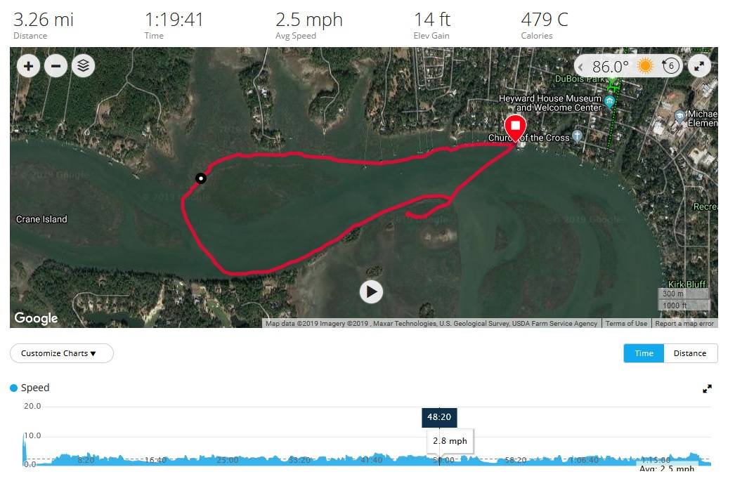
Charlie, I think I did misread. My apologies. I use a Garmin Vivosmart HR+. Here’s a screenshot from the Garmin Connect website - there is also an iPhone app that shows pretty much the same data - for a (lazy) paddle my wife and I recently did…
The red line represents our track. The black and white dot on the track shows our position at the time of the details below - we were 48min and 20 seconds into our trip and we were doing 2.8mph. I can move that black and white dot to any point along the track with my PC’s mouse. The full trip details along the top show our totals.
The full display on the website also shows my heart rate and a bunch of other stuff.
@CharlieK said: @raisins Wow! Thank you very much for posting that! That is exactly what I’m looking for! What GPS do you use? My only experience with GPS is with either google maps on my android… or the Garmin in my car, or the Garmin Dezl in my semi’s.
yes, I use a GPSMAP 78, but, any handheld (or other) will work, if you have access to the ‘data’.
With the Garmin handhelds, you download the data to your computer, open your app (eg Garmin Basecamp), and do what you want with the data.
not familiar with the Forerunner, can you download your tracks from it?
not familiar with gps apps on smartphones. Does one have access to the data or are they dependent on the ‘presentation’ (tools, charts, whatever) provided by the app.
Forerunner presents maps and data the same way as shown in kfbrady’s post using Garmin Connect. I’ve used it for tracking on seven-hour paddles with no battery life issues. Not sure I could say the same for my iPhone.
@raisins said:
yes, I use a GPSMAP 78, but, any handheld (or other) will work, if you have access to the ‘data’.
With the Garmin handhelds, you download the data to your computer, open your app (eg Garmin Basecamp), and do what you want with the data.
not familiar with the Forerunner, can you download your tracks from it?
not familiar with gps apps on smartphones. Does one have access to the data or are they dependent on the ‘presentation’ (tools, charts, whatever) provided by the app.
Is it possible to track where a GPSMAP 78 is? I’m talking about something similar to “sharing a location” with google maps on my android. Can you “share” your location with your smart phone? Because it’ll take significantly longer for the GPSMAP 78 to travel down stream, I’d like to send it off on its way, and then later, go and catch up to it. But… that only works if I’m guaranteed to find it!