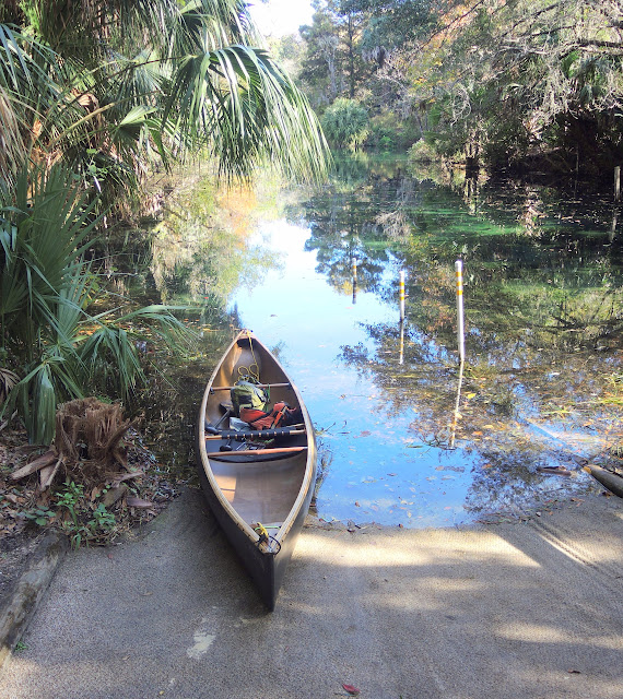
I have paddled the Juniper Springs Florida run a couple of dozen times and love it. Each time I reach the take out I say to myself that the next I go I should put in at the take out and head downstream and take out at the boat ramp on the St. John’s River.
Has anyone done this section before? Looking at the maps it looks like a long drive down a dirt road to get to the boat ramp. Was wondering what kind of shape this road is in. I have found riding around in the Ocala National Forest that some dirt roads are in much better shape than others. Anything else I should know about before trying this section?
Lastly, anyone interested in joining me paddling this section?
Kayak_Ken
Why not paddle down and back up
I’ve paddled down about a half mile from the Rte. 19 take-out and back up. There wasn’t much current. You can probably easily paddle all the way to Lake George and back up.
It was very low and choked with vegetation at Rte. 19 in November 2014 – the lowest I’ve ever seen it.
Rivers running high now
I’ve done Juniper 3 times now and taken out at 19. River very low after when I did it.
You might get lucky this time
My wife and I have done it…
down to Lake George and back, but that was a long time ago.
It was the only time in my life that I saw gators mating, and they were not too happy with us disturbing them
The up coming week looks crummy weather wise or we would join you.
We were just at the Silver River today and any one who hasn’t done it in a few years is going to be mighty PO’d when they paddle it again.
Jack L
Why?
A zoo?
Hey Ken,
I’ve never paddled that section, I figured it belonged to the air boaters. I’d certainly be willing to consider joining you for the trip if our schedules align. I’ve got a trailer to make shuttling quite easy.
Kayakmedic, the Silver is murky right now, not the crystal clear beauty is should be. We’re thinking it’s road construction. The springs are still running clear, thank God. And baby monkeys are always cute!
T
I am going to try to be down that way
The next two weekends. Could go paddling on Saturday April 11th or Sunday April 19th. Are you free for either one?
Ken
Jack…
I’ve paddled the Silver 4 or 5 times but not since the state took over the Silver Springs Park. Please tell me if I should not make the long drive down. What happened?
Pag
The head springs are as beautiful…
as ever and they have opened up a canoe trail that used to be off limits.
The monkeys are still there -We saw two bands of them
The bad news; After you launch and go down the canal, when you turn into the Silver you will no longer see clear water. it is dark gray- almost black.
This lasts for four miles. then it slowly clears up, and you can start to see that beautiful green underwater grass.
The only problem is it is covered with black silt for another half mile or so before it gets clear.
I am blaming in on the construction they did on the road way a few years back when they made humongous holes on the side of the road to " capture the road way surface runoff and filter it".
I thought then when I saw earth movers down in the deep holes that they had to be disturbing the water table and some one must be nuts
I talked to an old time guide and he also blames it on that same construction. - He asked me to write a letter to the St. John River Water Management Agency, but to me the damage is done and the river will never be the same
I doubt if I’ll be going back. My number one favorite river is no longer number one.
If you do go, just put in at the head spring. There now is a rental place there.
It would be a waste paddling up stream in what used to be pristine crystal clear spring water.
Jack L
That is just awful
I wonder why the State allowed such runoff of silt? No barriers?
They had barriers all over the place
Their holes were so deep that I believed they went into the water table and screwed it up.
I am sure they will have some CYA “expert engineer” say it is not what they did, but to this old retired do-it yourselfer, it was kind of obvious at the time.
Others may differ!
I just never thought it would be this bad
Jack L
Lower Juniper
The Aquaholics just paddled lower Juniper a couple of weeks ago to the take out on Lake George. The dirt road was in pretty good shape then. As far as the Silver River being murky I’m sure it will clear up. It was clear two weeks ago when I was on River Patrol. Not sure what is going on… I know when there is any disturbance in Half Mile Creek it turns the rest of the river to muddy waters down stream. I was at the riverside launch doing surveys yesterday & it was clear near the launch.
you can read about it
The runoff is from “Half Mile Creek”.
The project was an attempt to mitigate the pollution from SR40. “Silver River Pollution Reduction Project” is the name. They didn’t just go digging holes for the hell of it. The water discharging from half mile creek into the river was nasty.
Have you ever paddled the river during the wet season? This winter has been about the wettest on record in addition to last summer and fall having been very wet up that way. So the water quality is going to be a lot different this year than during most dry seasons. Obviously their project has been overwhelmed but the I don’t think it can be blamed entirely on the poor water quality downstream of Halfmile Creek. It always got bad after lots of wet, that’s what the project was done.
Here’s some historical perspective on why the project was undertaken:
http://www.ocala.com/article/20081219/ARTICLES/812199995
Anyone really concerned with the health of the silver river should consider both stormwater runnoff, overpumping of the aquifer, and the chronic nutrient loading that has led to a massive reduction in eel grass coverage and overabundance of filamentous algae over the last couple of decades.
Quality of the water below Halfmile Creek is made worse when Halfmile is making significant discharges of surface runoff while the spring itself is discharging at very low levels because the aquifer is still down from the multiyear drought that affected the basin from 2009 through early 2014.
thanks for the info
we’re coming next month and will paddle the river…
Hi Phyllis
How come we didn’t see you yesterday ?
Some girl from Florida State or some University asked us to take a survey which we gladly did.
Either you were drinking too many margaritas or I was drinking too many margaritas, but when we put in at about 9:30 Am and when we took out about 4:00 pm the gray/black water started where the canal meets the river and then all the way up for four miles.
I looked for your e-mail to write to you about it, but we don’t have it.
Talked to that old timer that takes tours and he blamed it on the construction also.
jack L
I have paddled it every year except
last year for the past fifteen or twenty years.
Somnetimes spring and other times fall.
I have paddled it this time of year like yesterday and have never seen it like it was.
One time about four or five years ago it was so flooded that we could paddle way into the woods and yet the river was still crystal clear.
Could locals be closing there eyes to what is happening ???
Jack L
I was at the
– Last Updated: Apr-05-15 12:42 PM EST –
state park river side launch doing surveys. If you had stopped there you would have seen me. I think I saw you & Nancy pass by on the way up & back. A red & white & an aqua & white QCC. We paddled the Ocklawaha on Friday when I noticed how muddy it was. Near the bank at the riverside launch on Sat. it was clear, but that is out of the mainstream current. Usually it gets muddy when we get a lot of rain... but no rain this week. Even then it clears up within a week or so. I'm still trying to find out what is going on. Capt. Tom is the old timer you probably saw yesterday. If I find out what is going on I can let you know. It will not stay muddy though.
No margaritas for me. Sangaria though when I got home.
Silver R. issue sounds like rain runoff
I paddled the Silver in mid-November 2014 and the water looked to be about its normal clarity. It also looked low.
All rivers I’ve ever seen anywhere become silty when there’s lots of snow melt or rain runoff. If there’s been lots of rain since November, that could explain it, especially the documented runoff from Half Mile Creek.
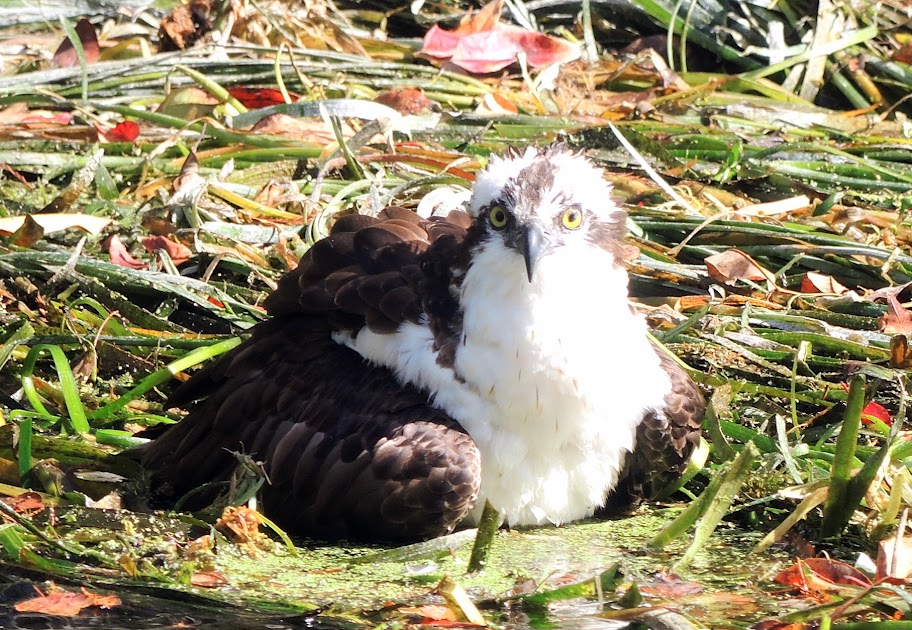
Here are November 2014 pictures of the new put-in at the head spring
http://lh5.googleusercontent.com/-zTBpAsUTgQY/VROgaVicjUI/AAAAAAAAC18/_T1O_5of2bA/s640/DSCN2387.JPG
and of what I believe to be an Osprey.
http://lh4.googleusercontent.com/-tvhKSDw790A/VQp9-hE_OBI/AAAAAAAAC0o/08RLbpC6XCw/s912/DSCN2396.JPG
What I saw wasn’t run off
I have paddled it during, before and after rain.
Besides it has been dry in this area for a while
Take your picture and make the color of the water dark gray with no clarity at all, and that is what the first four miles from Ray Wayside looked like.
Where did you put in ?
Jack L
PS: Sorry Kayak Ken I didn’t mean to steal your post !
Maybe runoff isn’t the right word
What else could it be except dirt/silt suspended: (1) directly in surface rain runoff, or (2) indirectly in the underground aquifer due to rain water somehow penetrating underground. That seems to cover the two most likely logical possibilities.
It’s too bad in either case, but I can only say that the water wasn’t noticeably bad in the Silver in November. The Ocklawaha, like all AmSouth brown and black water rivers lacked clarity. And by the way, I wouldn’t let water clarity affect my decision to paddle AmSouth rivers. The (usually) crystal clear spring runs are the exception.
I paddled from the Silver head spring to Rays channel and back. I really wouldn’t recommend that in retrospect, as I prefer to go upstream first and have the last half of the trip physically easier going downstream. Maybe the water was murkier down near Rays, Jack, but I really didn’t notice.
There weren’t any monkeys either. Here are some cursed ones:
http://www.youtube.com/watch?v=lLijM7SVBL0