Solo 89 miles Key River to Fox Islands and Burritts Bay near Byng Inlet, May-June 2024
I’d put this in Go Paddle but it doesn’t support photos.
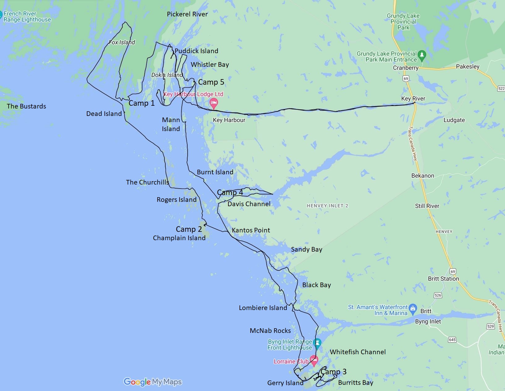
The Sudbury weather forecast showed six days of decent weather at the end of May and into June. I drove to Parry Sound and then early the next morning to Key River Marina, where I paid for parking and launched before 9. The “river” here is an eight mile long narrow inlet on Georgian Bay. The only evidence of a current is the water weeds pointing toward the bay.
Day 1, Wednesday: My first destination was Key Harbor at the mouth of the river at the northeast corner of Georgian Bay. Parts of the river are narrow with granite walls dropping into the water and topped by craggy white pines. The south shore is Henvey Inlet First Nation Reserve, no trespassing. Except for a few cottages reachable only by water, the north shore is French River Provincial Park. French River campsite 700 is five kilometers from the marina.
Shortly after the campsite the scenery changed. Wind turbines loomed on the south shore, part of an 80 turbine wind farm installed on the reserve. The shorelines dropped and the south shore was a skeleton of trees from a forest fire. A little further on the fire barrens covered both shores. There were a few surviving patches of forest and scattered sentinel pines. I know fire is a natural part of the ecosystem but skeleton river was depressing to paddle through.

Green forest returned about a mile from Key Harbor. Key Harbor itself has cottages of all ages and sizes, all with docks and house numbers along the river. Most had not been opened up yet for the season. The commercial establishment is Key Harbor Lodge. Its signage lists groceries, ice, gas, fishing licenses and tackle. A little further out are wharf pilings and a large ruined concrete building from the days when Key Harbor had a rail spur to service the mines at Sudbury. Today boats are the only way to get to Key Harbor.
I entered the channel between Dokis and Puddick Island where I had lunch at noon after ten miles. I intended to explore Sand Bay and the Pickerel River but as I went north the mainland was all fire barrens. I asked a fisherman on Bowens Bay if the fire extended up the Pickerel; the answer was “as far as the eye can see”. At this point I was starting to regret my choice of Key River.
I turned back south past Dokis Island and headed for a peninsula on Dead Island Channel that had three French River campsites. The first two were burnt and I saw no sign of them; site 712 was right at the edge, the very tip of the peninsula having been spared by the fire. I arrived there at two thirty and set up camp. For the first time I pitched the tent on flat rock, holding the stakes with stones, rather than on a flat spot of real ground. This is popular practice along Georgian Bay and it worked well; a little hard on the knees but the usual dirt and pine needles stayed out of the tent and sleep is comfortable with an air mattress. The stars and the Milky Way were brilliant that night.

The Fire: The forest fire has a name, Parry Sound 33. It occurred in 2018 and burned 42 square miles. Much of the area no longer has any soil. It was started by crews that were installing the wind farm on the Henley Inlet Reserve. The devastation is not apparent on Google maps but appears on Google Earth. Fire map (green is French River PP, pink is Henvey Inlet First Nation): https://x.com/cbcdaveseglins/status/1027548678788194305?lang=en
Day 2, Thursday: I left camp before seven to beat the north winds which would be picking up until late afternoon. I headed west and was relieved to see no burn. Circumnavigated Fox Island through some very scenic channels and headed back through the Outer Foxes to pit on Dead Island, a beautiful and peaceful place. A sailboat left the shelter of a bay on Dead Island that morning; other than that the only other boats I saw on the trip were fishing skiffs, runabouts, and a few cabin boats.

Southeast from Dead I threaded through unnamed islets to the Churchills, filtering water on the way. There are some nice campsites (look for rock fire rings) on the west channel between two of the three biggest Churchills. Then I passed Rogers Island to Champlain Island, where I found a good campsite on the island’s northeast bay at noon. The bay to the south features a large piece of metal machinery and riveted tanks and boilers, possibly a winching system, although the bay seemed too shallow for sizable vessels. The view toward the mainland was a few distant houses and the ever present wind turbines. To the west was the Bustards, the western-most destination of my previous Georgian Bay trip. As at most of the sites that I visited there were lots of flowers (especially blueberry) and pine pollen was rafting in places.
Day 3, Friday: Sunrise over the turbines was beautiful but the wind was blowing, not a good sign.

It was predicted to shift from the west and become a lot stronger. I left shortly after six. The passage to the mainland at Kantos Point and from there to the lee of Cedar Island featured swells from both the northwest and west, stacking to two feet. The water was 65 degrees and I was glad to have a dry suit. Pit stopped at Lombiere Island to scout the course across Byng Inlet to the lighthouse. I followed the shore east for a mile and crossed toward Bigwood Island. This part of the inlet was well protected by the outlying McNab Rocks.
I explored the lighthouse’s Gereaux Island and Whitefish Channel. By this time the winds had increased to twenty mph and there was no way around Gerry Island (which turns out to be a peninsula) that didn’t involve a howling wind and breaking waves. In searching for a passage south to Burritts Bay I discovered a beautiful site on Dorothy Island and made camp. I found I could reach Burritts with a 50 yard portage, so I carried the empty kayak and toured the bay. Burritts had lots of fishermen in spite of the gale. The area is so scenic that I found myself wishing I had put in at Britt on Byng Inlet and headed south to Naiscoot instead of starting at Key River; no burn or turbines here. Maybe next time.

Despite the wind the campsite’s channel was calm and 70 degrees. I went swimming with my paddling boots on; they have grippy soles but the rock was slippery under water and I had to find an alternate route out. That evening the mosquitoes got thick for the first time and I hunkered in my Permethrin-treated tent.
Day 4, Saturday: Calmer winds today as I headed out of Whitefish Channel.

Overnight the kayak was parked on a patch of grass and moss on the smooth rock. It was covered with dozens of small slugs. I flicked as many off as I could, but for the first hour they kept appearing on deck and I kept flicking them off. If a fish had followed me back across Byng Inlet he would have feasted on mollusk meat.
Heading back north I toured Black Bay and Sandy Bay and pitted after Free Drinks Passage (what a name!) to shed my personal sauna, aka dry suit. The islands at the mouth of Henvey Inlet are beautiful but to the east the north shore was back to fire barrens. I planned to visit The Flowerpot halfway up the inlet but the north shore was burnt and an aerial view showed a wind farm access road along the shoreline so I turned back. I found a great campsite on the north shore of an island off Davis Channel before noon. Along with the usual fire ring and grills it came equipped with a cast iron skillet, barbecue tongs and a spatula. It also had a cheapo chair that was more comfortable than mine and had a sweeping view of the inlet to the north.

The afternoon’s entertainment included a mink, long lines of geese heading north (don’t they have babies yet?), a sea plane taxiing out of Davis and taking off in front of me, and exploring a cove dammed by a straight line of mud, sticks, and rocks that seemed way too big for beavers to move.

All of this was accompanied by a steady hum from a wind turbine more than a kilometer away.
Clouds rolled in before sunset; the forecast called for a.m. showers but they arrived early.
Day 5, Sunday: The camp on Henvey Inlet was only a few miles from Key Harbor. My goal for the day was to explore more and find a campsite close to the harbor so that I could get to the car early the next day for the long drive home. I headed north past Burnt Island and through a patch of skerries where I scraped several times. This no boating area is a huge hangout for gulls and pelicans.

Continuing north past Mann Island, I meandered through Whistler Bay and the channels around Puddick and Dokis islands through occasional sprinkles.

A beautiful channel on the west side of Dokis had a promising campsite. Instead I chose an island north of Germain that I dubbed Crab Claw Island due to its shape. It would have fewer mosquitoes and it was a mile closer to Key Harbor. While there are houses nearby, none were visible from camp and only part of the view was burn barren. The island is unusual in that it is easy to walk from one end to the other.

The clouds cleared out in time for a nice sunset punctuated by the sound of songbirds, frogs, loons, gulls, geese and cranes.
Day 6, Monday: I was on the water in the fog at 6:15 for the ten mile paddle back to Key Harbor Marina and my car. The water was thick with fish flies and a few boats went by on Key River. Cottagers trade boats for cars at the road and a marina there still had hundreds of boats stored. I imagine that traffic gets pretty heavy in season in front of French River site 700. I was on the road again at 9:30.
Overall this was a good trip, but due to the fire barrens I preferred previous Georgian Bay trips over this one:
Consider putting in at Britt instead of Key River as the area south of Byng Inlet was beautiful.
Paddling at the end of May has its pluses. Black fly season is over and the mosquitoes are just starting to get bad; I highly recommend pre-treating outerwear and tent with Permethrin. I saw no other paddlers, so campsites were empty and no yachts infested the coves. Marinas are open but boating traffic doesn’t overwhelm until July. Lots of flowers were blooming including starflower, lady’s slipper, blueberry, columbine, Canada mayflower, and mountain ash. Seventeen hours of daylight are a big plus over August trips. On the other hand big water temperature was 65 degrees, too cold for swimming and too warm for beer. Morning air temps were in the 60s which meant sweltering in a dry suit and PFD. And it got down to 40 the first night; I was comfortable in my three season sleeping bag wearing sweats and a wool hat.
Canada topo maps are available gratis at GeoGratis spatial product index I used raster 1:50,000 tifs 041H15 Key Harbor and 041H10 Naiscoot River, cropped, printed double sided on heavy paper and sealed with a Scotch laminator.
I rely on a free phone app called Geo Tracker to help navigate and to track my route.
 It works with or without cell coverage. I paid Mint Mobile about $30 for ten days service in Canada and had anywhere from zero to three bars during the trip.