Five Day trip in Georgian Bay on Lake Huron From Bayfield Inlet to Norgate and Shawanaga inlets August 2024

The weather forecast showed six sunny days with low winds. By the time I drove to Bayfield Inlet it had changed to five sunny days and the day’s wind forecast was 30 kph, about 16 knots. The recommended launch at government dock was not going to happen; it was surrounded by No Parking signs. I ended up putting in at Thompson Marine, $10/day to park.
Day 1, Monday: My first destination was north to Foster Island, but I was not going to get there in open water in those winds. I paddled up the south channel of the Naiscoot River, which was pretty and undeveloped and had several campsites. The plan was to get to the river’s north channel and then take Mud Passage out to the bay, which would give me a protected run to Foster. Plans change.
The book Kayaking Georgian Bay says that the passage to the north channel is hard to find. Yup. The area is marsh and the marsh grass is higher than eye level from a kayak seat, so visibility is limited. Its the type of terrain that screams of moose and blood sucking insects. At one point I found myself following a two-foot wide ditch in my 22-inch wide kayak with the occasional mud pile on either side. Beaver path! It dead ended and I had a tough time backing out around the turns. Before giving up I landed at the closest place that wasn’t surrounded by marsh mud and got out. From that vantage point a spot of water was visible in the grass; it just might be a channel leading away from me. Sure enough, it got me to the north channel.

I paddled up to Mud Passage and had lunch.

The passage looked like it might be passable on satellite views, but Google Earth can’t tell you how deep the water is. It turned out to be about two inches of water over peat. I gave up when forward movement pushed the peat up above water on either side of the kayak.
Paddling out to the bay convinced me to not head further north that day; waves were breaking on shallows a half mile out,and no inside passage was apparent. I turned south and followed a channel west of Chicken Liver Channel, scraping at several spots. This area at the edge of open water is typical – long low (maybe 2 foot high) glacier-smoothed granite shelves, completely barren and sometimes extending out for half a mile before they go underwater deep enough to paddle over. Waves were breaking even farther out and rise high when they hit the shallows. Inland the islands gain some soil and stunted eastern red cedars dominate. Further inland you see higher ground and white pines, which provide much needed shade and beauty. You have to be very careful paddling in the shelves to avoid running aground, and its difficult to see where there might be a usable passage so the going is slow. “When in doubt go further out”. But going out in waves can drop you onto rock in a trough. I don’t mind paddling the shelves when the wind is calm but the overall vibe is one of desolate beauty.
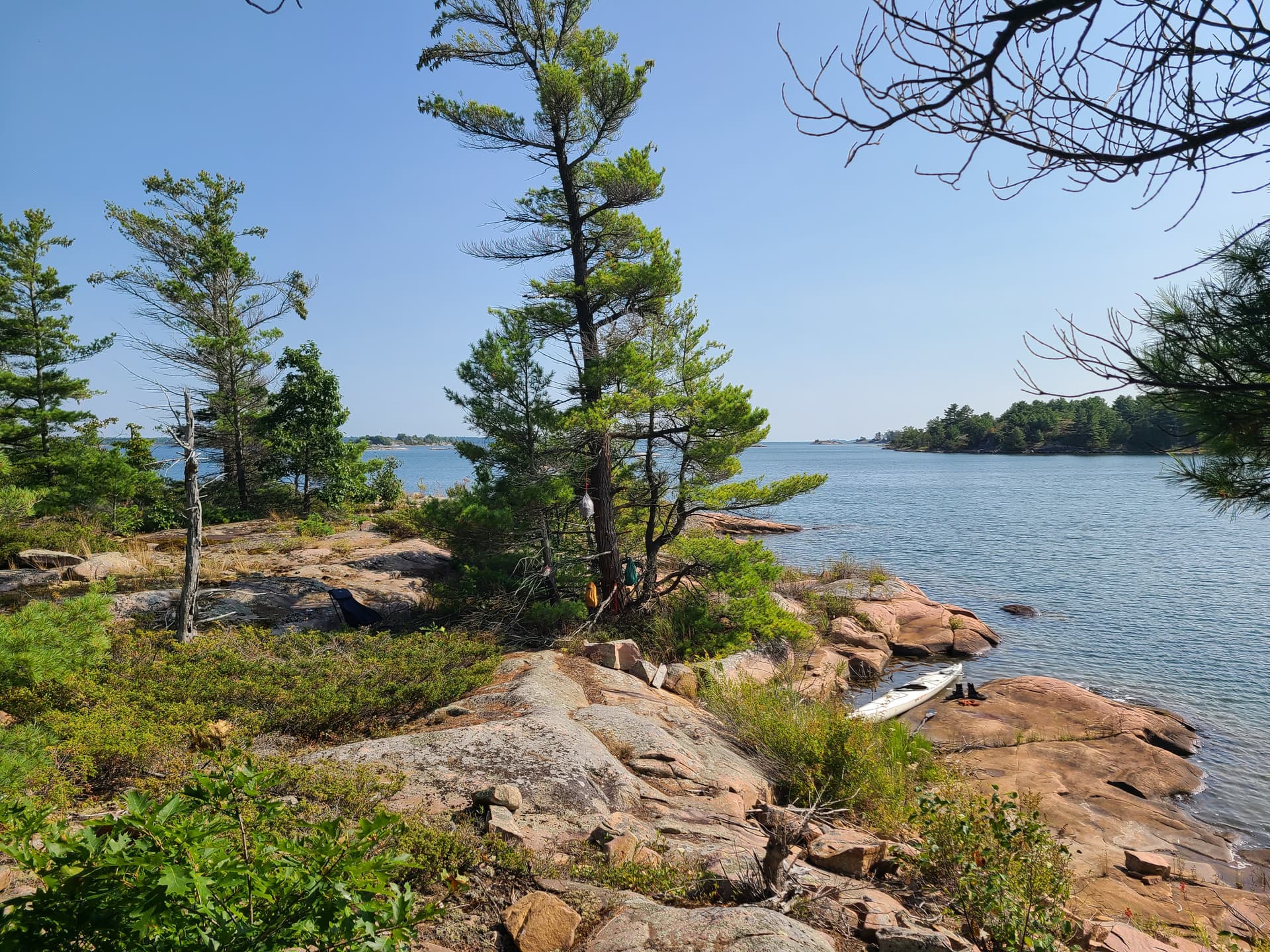
I found a great campsite, marked by the usual rock fire ring, on a small shallow bay that no motorboat could ever get into. It featured a beaver that was working diligently during daylight hours.

After making camp I explored the area and discovered my doppelganger, John, at a nearby campsite. He too was paddling solo in a white kayak, and turns out we have both paddled the same places in Georgian Bay.
Day 2, Tuesday: When I left camp at 7:30 there was almost no wind. I headed out past the shelves and then north past the west end of Mud Passage. The outlying Bouchier Island chain, mostly barren or cedar, featured a house with an old Chevy parked out front. I’m guessing it was driven there one year when the ice was thick. According to John the bay doesn’t freeze anymore.

From the Bouchiers I crossed Norgate Inlet and threaded between islands almost to Burritts Bay, the farthest south on my previous trip. Then I turned back south and took a more inland route into Prisque Bay and around Foster Island. This remote area has very few houses, almost as wild as French River, and the scenery is gorgeous. I could spend a week there.

As I continued south I saw another kayak on the shore past the Naiscoot, and found a great campsite on the south shore of Charles Inlet. This one featured the usual rock ring, a nosy mink, a deep spot suitable for diving, and another beautiful sunset.

Day 3, Wednesday: The goal today was to head south to Shawanaga Island, crown land south of Point Au Baril. To get to Point Au Baril you take Hangdog Passage. This turned out to be well-marked – Red Right Return back to Bayfield meant green on right to head south – and it was nice not to have to slow up worrying about hitting solid granite lurking just under the surface. However, the south end of the marked passage heads out the shelves; I was able to paddle the eastern-most narrows and avoid much of it. In fact, except for a quarter mile right near the lighthouse the way is well protected.
The story is that Point Au Baril gets its name from a barrel that housed the first light on Georgian Bay. Now there is a real lighthouse but the barrel tradition is kept alive.

The area is highly developed with cottages and mansions on every island. There is even a grocery store on Ojibway Island. On August weekends the boat traffic must be intense. The most interesting place is labeled “Hole in the Wall” on Google maps. It is a narrow passage on the north shore of Shawanaga Island that has both sand beaches (rarities in Georgian Bay) and an almost ideal cliff diving spot. The main channels have lots of sailing yachts and large cabin cruisers, many with Great Loop burgees. In fact, the biggest waves I encountered on the trip was when two cabin cruisers passed each other and I happened to end up where their wakes crossed; they stacked up and washed right over my foredeck. Some of the less-developed bays are yacht anchorages and I ended up camping at one of them, a cove off Shawanaga Inlet on Nadeau Island.
Day 4, Thursday: There was a spectacular sunrise lighting up the mist across Shawanaga Inlet.

The forecast changed. 20 mm of rain, T-storms and high winds Friday evening. Instead of the planned day trip south to the McCoys I decided to head back; packing up in the rain is worth avoiding. I took a different route back to Point Au Baril and got to watch a seaplane take off.
Nares Inlet, just north of Point Au Baril, turned out to be an interesting place. A building on the south shore that looked like it was still being framed turned out to be a caged pickleball court. There was a decent campsite across from it. A little further on I saw something curious on Cratloe Island and, seeing a fire ring and no house, got out to take a look. It was on a sizeable bay with no houses. The curious object turned out to be a composter with instructions in French. I had intended to paddle a lot further but I couldn’t pass this site up; it was too beautiful.

After making camp I explored the rest of Nares Inlet. It has a few houses scattered on it and a marina at the east end. I saw several campsites along the shore, parked yachts, and a remote narrow arm was well worth exploring.
During happy hour a canoe entered the bay with a small child fishing in the front and probably his grandpa paddling in back. I waved. He said “You are on my land” (heart attack!) “but you are welcome to it” (whew!) “just be careful with fire”. I’ve encountered welcoming attitudes from residents before while paddling and I really appreciate this great guy. The composter was gifted to him by his nephew from Montreal; it was large enough to be used by the local community. And a previous camper had a fire get out of control there, though I saw no signs of it.
Day 5, Friday: Time to head home. Cratloe Island camp is near Hangdog Channel and about five miles from the Bayfield Inlet marina. I followed the channel past the shelves and then took a more easterly route north through very pretty narrow channels.

I was surprised how few houses there were this close to the marina. Turns out Gibraltar Island and the bay next to it are crown land. I was on the road by 9:30.
I was sad to cut this trip short but I’m glad I did. I drove though a one hour white-out deluge on the way back to Michigan, and CBC had coverage of flooding in Toronto and Montreal the next day. I saw only two other kayak campers during the trip, plus a handful of day paddlers around Point Au Baril. Afternoon temperatures were in the 80’s, water was in the mid-70’s. I started early each day and was making camp around noon or one.
Resources
Previous trip reports:
Canada topo maps are available gratis at GeoGratis spatial product index I used raster 1:50,000 tifs 041H15 Key Harbor and 041H10 Naiscoot River, cropped, printed double sided on heavy paper and sealed with a Scotch laminator.
You can identify private vs crown land at this website, albeit not very easily. You have to zoom in before property lines will appear and it can be difficult to differentiate between property line and shoreline: Ontario Map Viewer
I rely on a free phone app called Geo Tracker to help navigate and to track my route.
![]() It works with or without cell coverage. Cell coverage was minimal around Norgate Inlet, strongest in Shawanaga Inlet.
It works with or without cell coverage. Cell coverage was minimal around Norgate Inlet, strongest in Shawanaga Inlet.